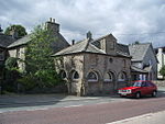
Keld, Cumbria
Cumbria geography stubsHamlets in CumbriaShap

Keld (or Keilde) is a hamlet in the English county of Cumbria. It lies within the civil parish of Shap. On the banks of the River Lowther it is a mile southwest of Shap and falls within that village's civil parish, Shap Abbey is nearby. Keld's medieval chapel (right) is noted for its unusual simplicity.
Excerpt from the Wikipedia article Keld, Cumbria (License: CC BY-SA 3.0, Authors, Images).Keld, Cumbria
Thornship Lane,
Geographical coordinates (GPS) Address Nearby Places Show on map
Geographical coordinates (GPS)
| Latitude | Longitude |
|---|---|
| N 54.523 ° | E -2.691 ° |
Address
Thornship Lane
Thornship Lane
CA10 3QF
England, United Kingdom
Open on Google Maps


