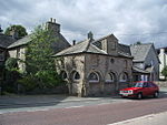
Shap railway station
Beeching closures in EnglandDisused railway stations in CumbriaFormer Lancaster and Carlisle Railway stationsPages with no open date in Infobox stationRailway stations in Great Britain closed in 1968 ... and 3 more
Railway stations in Great Britain opened in 1846ShapUse British English from March 2017
Shap railway station served the village of Shap, Westmorland (now in Cumbria), England for over 120 years.
Excerpt from the Wikipedia article Shap railway station (License: CC BY-SA 3.0, Authors).Shap railway station
Oak Tree Close,
Geographical coordinates (GPS) Address External links Nearby Places Show on map
Geographical coordinates (GPS)
| Latitude | Longitude |
|---|---|
| N 54.523 ° | E -2.6706 ° |
Address
Shap
Oak Tree Close
CA10 3PW
England, United Kingdom
Open on Google Maps


