place

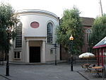
St George's Church, Worcester

1829 establishments in England19th-century Roman Catholic church buildings in the United KingdomBuildings and structures in Worcester, EnglandChurches in Worcester, EnglandGrade II* listed Roman Catholic churches in England
Grade II* listed churches in WorcestershireNeoclassical architecture in EnglandRoman Catholic churches completed in 1829Roman Catholic churches in Worcestershire
St George's Roman Catholic Church geograph.org.uk 580383

St George's Church is a Roman Catholic Parish church in Worcester. It was founded in 1829 and was administered by the Society of Jesus until 1990 when it was handed over to the Archdiocese of Birmingham. It is in the Baroque style, is a Grade II* listed building and was where Edward Elgar was organist from 1885.

Excerpt from the Wikipedia article St George's Church, Worcester (License: CC BY-SA 3.0, Authors, Images).

St George's Church, Worcester
Sansome Street, Worcester, England Red Hill

Geographical coordinates (GPS) Address External links Nearby Places
placeShow on map

Wikipedia: St George's Church, WorcesterContinue reading on Wikipedia

Geographical coordinates (GPS)

Latitude Longitude
N 52.1947 ° E -2.2195 °
placeShow on map

Address

St George's Catholic Church

Sansome Street
WR1 1UH Worcester, England, Red Hill
England, United Kingdom
mapOpen on Google Maps

linkWikiData (Q15979350)
linkOpenStreetMap (271846624)

St George's Roman Catholic Church geograph.org.uk 580383
Share experience

Nearby Places

Worcester city walls

Worcester's city walls are a sequence of defensive structures built around the city of Worcester in England between the 1st and 17th centuries. The first walls to be built around Worcester were constructed by the Romans. These early walls lasted beyond the fall of the Empire, and the defences encouraged several early Christian foundations to establish themselves in Worcester during the troubled 6th and 7th centuries. The Anglo-Saxons expanded Worcester in the 890s, forming a new walled, planned city, called a burh. The burh utilised the southern stretches of the old Roman walls, but pushed further north to enclose a much larger area. The Anglo-Saxon city walls were maintained by a share of taxes on a local market and streets, in an agreement reinforced by a royal charter. After the Norman conquest of England in the 11th century a motte and bailey castle was constructed on the south side of the city, but the Norman rulers continued to use the older burh walls, despite the city having expanded beyond these defences in the north and south-east. During the years of the Anarchy in the 1140s, Worcester was successfully attacked several times; after the war a new city wall was built to improve the city's defences. The new walls, completed by the early 13th century, were constructed of stone and had three main gates. They were maintained in good condition into the 17th century. During the English Civil War in the 1640s the old medieval walls were reinforced with modern earthwork bastions and an outlying fort, called a sconce. Worcester changed hands several times during the conflict, and after the war ended the newer fortifications were dismantled. During the 18th century the older medieval stone walls and gatehouses were sold and mostly destroyed: by the 20th century, few parts survived. Post-war archaeology in the 1950s and 1960s and construction work in the 1970s revealed previously hidden stretches of the wall, and in the 21st century plans have been drawn up to improve the conservation and maintenance of this historic monument.