Port Erin

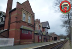
Port Erin (Manx: Purt Çhiarn, meaning lord's port) is a seaside village in the south-west of the Isle of Man, in the historic parish of Rushen. It was previously a seaside resort before the decline of the tourist trade. Administratively it is designated as a village district, with its own board of commissioners. The district covers around 1 square mile, and is adjacent to: Port St Mary to the south-east; the main part of Arbory and Rushen parish district to the north and east; the sea to the west; and an exclave of Arbory and Rushen parish district (including the village of Cregneash) to the south. Following recent residential expansion, the settlement is now contiguous with that of Port St Mary, and on 18 July 2018 Tynwald authorised a public enquiry into the proposed expansion of the district boundary to include some of this expansion.The village was twinned with Latour-de-France.
Excerpt from the Wikipedia article Port Erin (License: CC BY-SA 3.0, Authors, Images).Port Erin
Bridson Street,
Geographical coordinates (GPS) Address Nearby Places Show on map
 Continue reading on Wikipedia
 Geographical coordinates (GPS)
| Latitude | Longitude |
|---|---|
| N 54.086 ° | E -4.756 ° |
Address
Bridson Street
Bridson Street
Isle of Man
Open on Google Maps