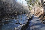
Varney's Falls Dam

Varney's Falls Dam is a historic lock and dam structure located on the James River near Gilmore Mills, Botetourt County, Virginia. It was built in 1851, and is a massive limestone structure. The lock chamber measures 100 feet long between gate recesses, 15 feet wide, and approximately 21 feet from the top on the upriver end to ground level. Associated with the lock are the lock and dam abutment structures, the remaining towpaths, canal bed, berm bank, towpath culvert and remnants of a towpath bridge. The dam was destroyed in 1881, and the lock gates removed in 1885.It was listed on the National Register of Historic Places in 1993. It is part of the James River and Kanawha Canal Historic District.
Excerpt from the Wikipedia article Varney's Falls Dam (License: CC BY-SA 3.0, Authors, Images).Varney's Falls Dam
Gilmers Mill Road,
Geographical coordinates (GPS) Address Nearby Places Show on map
Geographical coordinates (GPS)
| Latitude | Longitude |
|---|---|
| N 37.581111111111 ° | E -79.597222222222 ° |
Address
Gilmers Mill Road 4598
24579
Virginia, United States
Open on Google Maps


