place

Fairmount Park, San Diego

Neighborhoods in San Diego

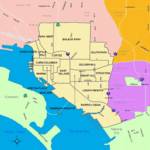
Fairmount Park is a neighborhood of San Diego, California. Its borders are defined by Interstate 15 to the west, Interstate 805 to the east and California Highway 94 to the south. Its neighboring communities are South Park and Golden Hill to the west, Azalea Park and City Heights to the east, and Webster to the south. It is primarily residential, mostly single-family homes, with a small commercial area along Home Avenue including several restaurants and convenience stores. Bayridge is a small neighborhood within Fairmount Park on its westernmost knoll, identifiable by its outstanding views and well-maintained townhouse development. Fairmount Park is 3 miles from Downtown San Diego. Chollas Creek runs through it.It is part of the City Heights community plan area and is located in city council district 9, represented by Marti Emerald.

Excerpt from the Wikipedia article Fairmount Park, San Diego (License: CC BY-SA 3.0, Authors).

Fairmount Park, San Diego
Midvale Drive, San Diego

Geographical coordinates (GPS) Address Nearby Places
placeShow on map

Wikipedia: Fairmount Park, San DiegoContinue reading on Wikipedia

Geographical coordinates (GPS)

Latitude Longitude
N 32.723138888889 ° E -117.10923611111 °
placeShow on map

Address

Midvale Drive 1720
92105 San Diego
California, United States
mapOpen on Google Maps

Share experience

Nearby Places

Gompers Preparatory Academy

South Park, San Diego

South Park is a neighborhood in San Diego, California adjacent to the southeast corner of Balboa Park. It stands out in San Diego for its tree-lined streets and walkable business district. Predominantly a single-family residence area with some small apartment buildings and bungalow courts, it is noteworthy for its fine and varied collection of Craftsman and Spanish Colonial Revival style homes built between 1905 and 1930. These include works by Irving Gill, William S. Hebbard, and Richard Requa. In 2017 San Diego designated the area of the original South Park Addition subdivision as the South Park Historic District, recognizing it as one of the best examples of an early 20th century streetcar suburb.The neighborhood is home to restaurants, cafes, grocery stores, taverns and wine bars, art galleries, the Albert Einstein Academy Charter School, and other local businesses. It is also home to Pathfinders, one of the oldest residential treatments centers for alcoholism in California. The main roads through South Park, forming its business district, are 30th Street, which was named the nation's best craft beer boulevard by Men's Journal, and Fern St. The neighborhood is dog-friendly and has one of the few designated dog parks adjacent to a residential area in San Diego.The South Park neighborhood is part of the Golden Hill Community Planning Area. The San Diego Police Department classifies South Park as a Central Division neighborhood bounded by Balboa Park on the west at 28th Street, Juniper Street on the north, A Street on the south, and Juniper Canyon and SR 15 on the east. It includes zip codes 92102 and 92104.