place

Poultry Cross (Salisbury)

Buildings and structures in SalisburyGrade I listed buildings in WiltshireMarket crosses in England
Poultry Cross, Salisbury geograph.org.uk 188948

The Poultry Cross is a market cross in Salisbury, Wiltshire, England, marking the site of former markets. Constructed in the 14th century and modified in the 18th century, it stands at the junction of Silver Street and Minster Street. It has been designated by English Heritage as a Grade I listed structure.The Poultry Cross is the only one remaining of four market crosses that once stood in Salisbury. The others were the Cheese Cross in the present Cheesemarket area, Barnard's Cross (livestock) at the junction of Barnard Street and Culver Street and another which designated a market for wool and yarn at the east end of the present Market Place, near the War Memorial.The presence of a market cross on the site dates to 1307, and the name to about a century later. The present stone structure was built in the 14th century. The original flying buttresses were removed in 1711, as can be seen in the painting of 1800 by J. M. W. Turner; the present buttresses date from 1852–1854, when the upper parts of the cross were rebuilt to the designs of the architect Owen Browne Carter.The present-day site, around the structure, is used as part of Salisbury Market on Tuesdays and Saturdays. However, the structure itself is no longer in use.

Excerpt from the Wikipedia article Poultry Cross (Salisbury) (License: CC BY-SA 3.0, Authors, Images).

Poultry Cross (Salisbury)
Silver Street, Salisbury Harnham

Geographical coordinates (GPS) Address Nearby Places
placeShow on map

Wikipedia: Poultry Cross (Salisbury)Continue reading on Wikipedia

Geographical coordinates (GPS)

Latitude Longitude
N 51.06876 ° E -1.79616 °
placeShow on map

Address

Silver Street
SP1 2NE Salisbury, Harnham
England, United Kingdom
mapOpen on Google Maps

Poultry Cross, Salisbury geograph.org.uk 188948
Share experience

Nearby Places

Old Sarum Way
Old Sarum Way

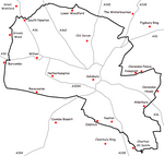
Old Sarum Way is a 32-mile (51 km) long-distance footpath in Wiltshire, England that forms a circle around the city of Salisbury. The route uses public roads, public rights of way and some newly created permitted paths. Some sections of the footpath are waymarked by a metal plate attached to wooden posts which show a picture of the cathedral spire. This is the best guess of the route (clockwise) based on surviving waymarks: SU074337 Head down the hill on the footpath, under the railway line then across the river into South Newton. SU088344 Climb the hill, passing the communication tower and crossing the A360. SU124353 Join the Monarch's Way. SU167337 Turn south. SU162329 Turn east into Old Malthouse Lane. SU170330 Turn south onto the bridleway; the path crosses the A30 and passes south on the hill above Laverstock. SU160297 Join the Clarendon Way. SU185302 Follow the footpath then the permissive path though the Clarendon Estate. SU193280 Turn south and follow Clarendon Lane then Folly Lane. SU183268 Turn onto the bridleway and pass south of Whaddon to SU195261. Turn south following approximately the disused railway line. SU194238 Turn west then join Witherington Road. SU189239 Turn onto the footpath through the woods and cross the river. SU176238 Join the Avon Valley Path northwards. SU129282 Turn left and head towards Salisbury Racecourse.The waymarks for the western section are missing. The most likely route is that the path crosses the A30 between Wilton and Burcombe, then heads north into Grovely Wood.