place

Garfield Avenue station

2000 establishments in New JerseyFormer Central Railroad of New Jersey stationsHudson-Bergen Light Rail stationsRailway stations in the United States opened in 2000Transportation in Jersey City, New Jersey
Garfield Avenue Station April 2015

Garfield Avenue is a station on the Hudson–Bergen Light Rail (HBLR) in the Claremont section of Jersey City, Hudson County, New Jersey. Located between the grade crossing at Randolph Avenue and the bridge at Garfield Avenue, the station in a double side platform and two track structure. The station is on the West Side Avenue branch of the Hudson–Bergen Light Rail, which goes from West Side Avenue station to Tonnelle Avenue station in North Bergen. The station is accessible for handicapped people as per the Americans with Disabilities Act of 1990. An elevator is present to get people from Garfield Avenue to track level and the platforms are even with the train cars. The station opened to the public on April 17, 2000 as part of the original operating segment of the Hudson–Bergen Light Rail.Garfield Avenue station is a block east of the former Arlington Avenue stop of the Newark and New York Railroad, a branch of the Central Railroad of New Jersey. This branch went from the Lafayette Street Terminal in Newark to the junction at Communipaw station in Jersey City, where it met up with the main line to Communipaw Terminal. Service on the line began on July 23, 1869. The station depot westbound at Arlington Avenue was built in 1889 and the eastbound station in 1910. Service to Newark ended abruptly on February 3, 1946 when a steamship knocked two spans of the bridge over the Hackensack River into the water below. Passenger service at Arlington Avenue ended on May 6, 1948.

Excerpt from the Wikipedia article Garfield Avenue station (License: CC BY-SA 3.0, Authors, Images).

Garfield Avenue station
Garfield Avenue, Jersey City

Geographical coordinates (GPS) Address Nearby Places
placeShow on map

Wikipedia: Garfield Avenue stationContinue reading on Wikipedia

Geographical coordinates (GPS)

Latitude Longitude
N 40.7105 ° E -74.071 °
placeShow on map

Address

Garfield Avenue

Garfield Avenue
07304 Jersey City
New Jersey, United States
mapOpen on Google Maps

Garfield Avenue Station April 2015
Share experience

Nearby Places

Berry Lane Park
Berry Lane Park

Berry Lane Park is a park created on a 17.5 acres (0.071 km2) of former brownfield site in the Communipaw-Lafayette Section of Jersey City, New Jersey. Construction of the park, which cost $38 million, began in 2012 and the park officially opened in June 2016. The park is located between Garfield Avenue and Woodward Street near the Garfield Avenue Hudson Bergen Light Rail station. Directly south of Berry Lane Park is Canal Crossing, an adjacent brownfield site slated for a future residential development. The park will be part of the greenway planned along the former route of the Morris Canal.Berry Lane Park is the largest municipal park in Jersey City. Features include two basketball courts, two tennis courts, a baseball field, a soccer field, a playground, a rain garden, 600 new trees, and a splash pad water park. New park features coexist with older existing structures that have been preserved or modified.The Berry Lane Park project site includes 11 properties formerly used as rail yards, auto repair shops, industrial facilities, and warehouses. The site required significant environmental investigation and remediation due to petroleum and heavy metal contamination. A former chromium processing plant operated by PPG Industries caused substantial Hexavalent chromium contamination on the Berry Lane Park property and other adjacent properties, but PPG Industries agreed to remove 700,000 tons of hazardous waste from this and several other sites in the area.Post-environmental remediation construction began on Wednesday August 22, 2012. The first and second phases of the project included final environmental remediation of contaminants and grading of the land as well as construction of the baseball field, and irrigation systems. The third phase of the project, which included installation of over 100 high-efficiency lights throughout the park, began in April 2014. The fourth phase of the project, which included completion of the turf baseball and soccer fields as well as construction of event spaces, began during the summer of 2014. The final phase of construction, which included concessions facilities, restrooms, basketball courts, a dog run, and other smaller park features, began after the fourth phase is complete. In October 2014, Jersey City received a $5 million grant from the New Jersey Economic Development Authority that will facilitate completion of a large portion of the park in a single phase. The park officially opened to the public in June 2016.Funding for the project includes grants from the United States Environmental Protection Agency (EPA), the New Jersey Economic Development Authority, Hudson County, a Community Development Block Grant from the U.S. Department of Housing and Urban Development, and the New Jersey Department of Environmental Protection (NJDEP).At the grand opening of the park, Jersey City, New Jersey mayor Steven Fulop announced a grant from the Tony Hawk Foundation to build a skate park. A new baseball field opened in October 2016. The skatepark opened in August 2020.

Canal Crossing, Jersey City

Canal Crossing is a New Urbanism project on the eastern side of Jersey City, New Jersey between Jackson Hill in Greenville/Bergen-Lafayette and Liberty State Park. The approximately 111 acre area, previously designated for industrial and distribution uses has been re-zoned for transit-oriented residential and commercial use and the construction of a neighborhood characterized as a sustainable community. The name is inspired by the Morris Canal, which once traversed the district in a general north and south alignment. The brownfield site must first undergo remediation of toxic waste, much of it left by PPG Industries The redevelopment plans call for 7,000 housing units, mainly "mid-rise" buildings (with heights limited to five stories), and a greenway along the former canal, directly south of the 17-acre Berry Lane Park. Two branches of the Hudson-Bergen Light Rail (HBLR) system create the northern and eastern borders of Canal Crossing. A new station at Caven Point Avenue is proposed on the line between Bayonne and Hoboken Terminal along its eastern perimeter between current stations at Richard Street and Liberty State Park. The triangular shape area is bounded by Garfield Avenue on the west, and is accessible from the Newark Bay Extension of the New Jersey Turnpike at its southern tip.In October 2010, the city received notification of a $2.3 million TIGER grant for continued work on the project. The funding was jeopardized by potential cuts being made in the House of Representatives, but was later allocated. A synopsis of the grant stated: Planning and design efforts will address modifications to infrastructure, subdivision of properties, zoning changes, and connections to the light rail stop and bike paths at Canal Crossing, a 111-acre redevelopment site in Jersey City surrounded by predominately minority households with high unemployment and poverty rates. Revitalization of this area has been hampered by outdated infrastructure, large tracts of contaminated former industrial lands, and a road system that fails to sufficiently link up with the local regional rail network. The project focus will be to create a residential, mixed-use, transit-oriented development with access to open space amenities in a community with a significant low-income population. The process will also develop a formal legal framework to ensure that redevelopment is equitable. PPG sued the United States for cleanup costs, arguing that the government's wartime control over the plant during both world wars exposed it to partial liability for the cleanup. The district court held in 2018 that the government's general wartime control of the plant was insufficient to create liability in the absence of a direct connection between the government and waste disposal activities. PPG has sued the Jersey City Redevelopment Authority stating that its redevelopment plans are hindered by that of the agency.In September 2019 it was announced that the Critierian Group would convert a warehouse in the district to the state's largest film studio.

Jackson Hill, Jersey City

Jackson Hill is a neighborhood in the Bergen-Lafayette and Greenville sections of Jersey City, New Jersey. It is part of the city's Ward F. The neighborhood is situated on Bergen Hill (the lower end of the Hudson Palisades) which also lends its name to the Bergen Hill Historic District just north of Communipaw Avenue. The district has long been the heart of the African American community in Jersey City. Its name is in part inspired by Thomas and John Vreeland Jackson, brothers born in 1800 and 1803, who were freed slaves who bought land in current day Greenville in 1831 and in 1857 laid out Jackson Lane between their houses. In 1900, the former Jackson Lane became Winfield Avenue, the name it bears today. During the Civil War the Jackson property became a safe house and critical link of the Underground Railroad.Martin Luther King Drive was once called Jackson Avenue. with a short block not included in a street realignment still bearing the name. In 1976 it was renamed in honor of the slain civil right leader Martin Luther King, Jr., who had twice spoken in the city. At the time of the renaming there was discussion whether the street had originally been named for the Jackson brothers or for US President Andrew Jackson. A 1924 Jersey Journal newspaper article ascribes it to Jeremiah Jackson, a local landowner in the mid-19th century. Historically, the avenue was one of the city's major shopping districts. but went into decline. In 2011, the Jersey City Redevelopment Agency created Jackson Hill Main Street special improvement district along the commercial corridors of MLK Drive and its northern continuation, Monticello Avenue.Among the notable sites in the Jackson Hill are two listed on National Register of Historic Places, St. Patrick's Parish and Buildings and Ficken's Warehouse, both on Grand Street. Sacred Heart Church and the Martin Luther King, Jr. Memorial are other area landmarks.

Martin Luther King, Jr. Memorial (Jersey City)

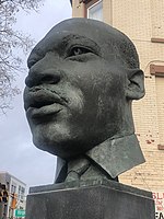
The Martin Luther King Jr. Memorial is a memorial to Martin Luther King Jr. at the Martin Luther King Drive station of the Hudson–Bergen Light Rail in the Jackson Hill section of Jersey City, New Jersey.The work — a bust and accompanying bas reliefs — was created by the sculptor Jonathan Shahn (1938-2020), who was son of Ben Shahn. It was commissioned by NJ Transit and unveiled in 2000 upon the stations's opening.The bronze 4 feet (1.2 m) bust is set atop a 7 feet (2.1 m) granite pedestal. Accompanying bronze bas reliefs, in 2-foot sections, entitled The Struggle for Civil Rights in the Martin Luther King Era, show scenes and figures from the civil rights movement. The reverse side is inscribed with a quotation from King's Letter from Birmingham Jail: "We know through painful experience that freedom is never voluntarily given by the oppressor; it must be demanded by the oppressed."King is known to have made at least two speeches in Jersey City. On September 21, 1965, he received an honorary Doctor of Law from St. Peter's College. Dr. King gave an address titled "The American Dream." On Wednesday, March 27, 1968, barely a week before his death, nearly 2,000 heard King at Metropolitan A.M.E. Zion Church in which her rallied support the Poor People's Campaign and the Memphis sanitation strike. The Afro-American Historical and Cultural Society Museum in Jersey City documents those visits.

Bergen Hill, Jersey City

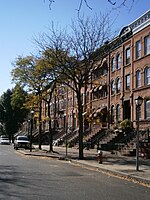
Bergen Hill is the name given to the emergence of the Hudson Palisades along the Bergen Neck peninsula in Hudson County, New Jersey and the inland neighborhood of Jersey City where they rise from the coastal plain at the Upper New York Bay. The name is taken from the original 17th-century New Netherland settlement of Bergen, which in Dutch means hills. Locally, Bergen Hill has sometimes been referred to colloquially as "The Hill" and was part of Bergen City, one of the municipalities that elected to merge with Jersey City in the 1860s, and is part of the section of the city known as Bergen-Lafayette. The neighborhood radiates from Communipaw Junction, at the intersection of Communipaw Avenue, Summit Avenue, and Grand Street where the toll house for the Bergen Point Plank Road was once situated. The avenues ascend the hill to the West Side, north to Five Corners, and south to Greenville. To the east is Communipaw-Lafayette and Liberty State Park. The Jersey City Redevelopment Agency has called the special improvement district along the commercial corridors of Monticello Avenue and MLK Drive the Jackson Hill Main StreetThe Bergen Hill Historic District received an opinion of eligibility for New Jersey Register of Historic Places designation (ID#1481) in 1991. It includes Summit Avenue and side streets which feature a mix of late 19th/early 20th architecture that includes brick rowhouses, brownstones, Queen Anne style apartment buildings and private homes. At the foot of avenue is Library Hall, a renovated 1866 building, now residences. It travels north to the landmark St. John's Episcopal Church soon after coming in the neighborhood of the Beacon, site of the former Jersey City Medical Center which since 2005 is being renovated and restored for adaptive reuse. Lincoln High School is on Crescent Avenue which, as its name suggests, arcs the neighborhood as is crosses Communipaw.To the south Grand Street ascends along Arlington Park, at the top of which is located the St. Patrick's Parish and Buildings at Bramhall Avenue. (40°42′50″N 74°4′23″W). While not in the state historic district, this complex received its federal historic status in September 1980 and anchors the surrounding streets, some of which are lined with well-preserved or restored 19th-century rowhouses. MLK Drive, formerly Jackson Avenue, has long been a commercial street for the southern part of the neighborhood, and is site of Hudson Bergen Light Rail station of the same name.The Claremont neighborhood lies south of Arlington Park, where before discontinuation of service the Central Railroad of New Jersey maintained station.