place

Lysaghts railway station

Buildings and structures in WollongongRailway stations in Australia opened in 1938Regional railway stations in New South WalesUse Australian English from May 2017
Lysaghts
Lysaghts

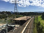
Lysaghts railway station is an intercity train station located in Spring Hill, New South Wales, Australia, on the South Coast railway line's Port Kembla branch. The station serves NSW TrainLink trains travelling south to Port Kembla and north to Wollongong and Sydney. The station is surrounded on both sides by the Lysaght factory at Spring Hill. Trains only stop on request. There is no way out of the station unless commuters work at the neighbouring steelworks. The station was one of 23 on the metropolitan rail network to record an average of fewer than one passenger per day in 2014.

Excerpt from the Wikipedia article Lysaghts railway station (License: CC BY-SA 3.0, Authors, Images).

Lysaghts railway station
Kembla Road, Wollongong City Council Port Kembla

Geographical coordinates (GPS) Address Nearby Places
placeShow on map

Wikipedia: Lysaghts railway stationContinue reading on Wikipedia

Geographical coordinates (GPS)

Latitude Longitude
N -34.4535 ° E 150.8759 °
placeShow on map

Address

Kembla Road

Kembla Road
2505 Wollongong City Council, Port Kembla
New South Wales, Australia
mapOpen on Google Maps

Lysaghts
Lysaghts
Share experience

Nearby Places

MacCabe Park
MacCabe Park

MacCabe Park is a small park located in the City of Wollongong, Australia. It is commonly misspelt McCabe Park, though the sign has since been changed to its correct name. In 1855 a land grant was made to Governor Brown, the present site of the park. It contains a playground at the north east corner of the rectangular area covered by the park, the local youth centre is in the north west side, and a sculpture called "Nike" is found in this area amidst a garden area. The youth centre has a small skating area and sometimes ramps and kickers are brought out, with a small number of fastened ramps present. The centre's walls are covered with graffiti and murals. A small strip of native plants and trees is present on the edge of the skating area. The northeastern area features a council operated art gallery and a war memorial, featuring a planted area and a canon. The west part of the park area features shops like Dick Smith bordering a narrow walkway underneath and between climbing plants. In the gaps between shops palm trees have been planted. Paths are present in the park and most of it is lawn grass. The southern end contains a man-made hillock with a smaller peak to its northern end and a larger slightly higher one at its southern end, with a circular amphitheatre of brick. In the southeastern and northwestern parts of the park are covered paths. In the eastern area is a community hall and carpark. The hall features a mural depicting a famous scene from E.T. The park area is surrounded by streets, the east side borders Church Street, Wollongong, the west side borders Keira Street, the north borders Burelli Street, and the southern end borders Ellen Street. The park is located in the southern part of Wollongong's central business district, only two blocks from Wollongong Central and Wollongong Mall. Plants in the park include palms, a few native eucalypts, grass plants, small grey leafed shrubs and a small planting of casuarinas south of the amphitheatre. Wollongong City Council has had a policy in place since 1990 to purchase the commercial properties surrounding the park as they become available. Eventually, these commercial buildings will be demolished to expand the public open space.