place

Isle of Axholme Rural District

Districts of England abolished by the Local Government Act 1972Districts of England created by the Local Government Act 1894Rural districts of LindseyUse British English from August 2012
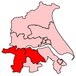
Isle of Axholme Rural District, Lindsey (1970)

Isle of Axholme was a rural district in Lincolnshire, Parts of Lindsey from 1894 to 1974. It was formed under the Local Government Act 1894 based on the Lincolnshire parts of the Thorne rural sanitary district and two parishes of the Goole RSD (covering the northern part of the Isle of Axholme). After the abolition of Crowle Urban District and taking in some parishes from the Gainsborough Rural District in 1936, it covered all of the Isle. It was abolished in 1974 under the Local Government Act 1972 and went to form part of the Boothferry district of Humberside. Since 1996 it has been incorporated in the unitary authority of North Lincolnshire.

Excerpt from the Wikipedia article Isle of Axholme Rural District (License: CC BY-SA 3.0, Authors, Images).

Isle of Axholme Rural District
Belton Road,

Geographical coordinates (GPS) Address Nearby Places
placeShow on map

Wikipedia: Isle of Axholme Rural DistrictContinue reading on Wikipedia

Geographical coordinates (GPS)

Latitude Longitude
N 53.55 ° E -0.8 °
placeShow on map

Address

Belton Road

Belton Road
DN9 1LY
England, United Kingdom
mapOpen on Google Maps

Isle of Axholme Rural District, Lindsey (1970)
Share experience

Nearby Places

Beltoft
Beltoft

Beltoft is a hamlet in the civil parish of Belton , North Lincolnshire, England. The village lies within the Isle of Axholme and is 4 miles (6 km) south-east of Crowle. There is a gas offtake from the National Transmission System at Beltoft, which is run by Scottish Power. It is connected by a 9.3-mile (15.0 km) pipeline to a gas compression station on Hatfield Moor, which pumps gas into a depleted natural gas field located 1,450 feet (440 m) below the moor. When more gas is required, the gas is extracted again, and re-enters the National Transmission System at Beltoft.The only public building in the village is the Methodist Chapel. In the 18th century, the Quakers were quite active in the area and had their own burial ground in the village. This site was reused by the Methodists, who built the first chapel there in 1833. That building was demolished, and a new chapel was built in 1904, and the premises were extended in 1923, when a Sunday School was added. The building sits on a wide plot, with a grassed area to the east of it, which was the former burial ground.Beltoft was one of the first villages to benefit from the third phase of the Northern Lincs Broadband initiative, a programme designed to ensure that rural communities were not left out in the provision of super-fast and ultra-fast broadband services. The multi-million-pound programme uses Fibre to the premises (FTTP) technology, which involves running fibre-optic cables from the telephone exchange into the business premises or homes of customers. Many other parts of North Lincolnshire will have a Fibre-to-the-Cabinet (FTTC) service, which provides super-fast broadband but not the ultra-fast service available in Beltoft. The scheme is funded by North Lincolnshire Council and benefitted from £2.9 million saved by efficiencies during the first phase of the programme.