place

Stocksundet

Geography of StockholmLandforms of Stockholm CountyStraits of Sweden
Stocksundet Bergshamra vattentorn

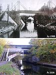
Stocksundet is a strait in Stockholm County in Sweden. It connects the Edsviken sea inlet, to the west, with the Lilla Värtan strait and eventually the Baltic sea, to the east. The strait also forms the border between the suburb of Stocksund in Danderyd Municipality, to the north, and the suburb of Bergshamra in Solna Municipality, to the south. The strait is approximately 2 kilometres (1.2 mi) long and varies in width between 90 metres (300 ft) and 250 metres (820 ft), whilst its depth varies between 6 metres (20 ft) and 15 metres (49 ft). Stocksundet is supposed to have received its name from the logs (Swedish: "stock") which used to be laid out in the water to stop invading ships in the Early Middle Ages. This name then led to the place name of Stocksund, on the north side of the sound, and to the heraldry shield of the then Stocksund Municipality between 1955 and 1966.By the 1400s, the road between Roslagen and Stockholm crossed Stocksundet, and by the 17th century, a ferry was provided. In 1716 the first bridge across the Stocksundet was built, principally to facilitate the movement of troops to the west in the event of an attack by Russia. Since then, there have been a total of seven bridges built across the strait.

Excerpt from the Wikipedia article Stocksundet (License: CC BY-SA 3.0, Authors, Images).

Stocksundet
Alnäsvägen, Solna kommun

Geographical coordinates (GPS) Address Nearby Places
placeShow on map

Wikipedia: StocksundetContinue reading on Wikipedia

Geographical coordinates (GPS)

Latitude Longitude
N 59.383333333333 ° E 18.040555555556 °
placeShow on map

Address

Björkhagen

Alnäsvägen
170 74 Solna kommun
Sweden
mapOpen on Google Maps

Stocksundet Bergshamra vattentorn
Share experience

Nearby Places

Ålkistan
Ålkistan

Ålkistan (Swedish: "The Eel Hatch") is the name of a canal, and the surrounding area, north of Stockholm, Sweden. The canal connects Lilla Värtan to Lake Brunnsviken, and delimits Bergshamra, the northern part of Solna, from the northern part of Djurgården. The name Ålkistan first appears on a map of Djurgården dated 1649, pointing out Åhlekijstetorpet ("The Eel Hatch Cottage"), Åhlekijstebackan ("The Eel Hatch Hillside") and Åhlekijste wijken ("The Eel Hatch Bay"). In a rivulet leading to the bay eels were caught using cages (in Swedish called kista, "coffin"), which gave the area its present name. The cottage is mentioned as a tavern in 1789.By the mid-19th century, mud threatened to cork the rivulet, which would effectively have turned Lake Brunnsviken, being used as refuse dump as it was, into a sewer. King Charles XV therefore ordered the present canal to be constructed in 1863, which lowered the water level of Brunnsviken by two metres. A 6.5-metre-wide (21 ft) wooden bridge with a mobile flap leading over the canal was added at the same time. The bridge was substituted in 1937 by a 23-metre-wide (75 ft) bridge with an 18-metre-wide (59 ft) roadway and a horizontal clearance of 8 metres, rebuilt in 1972.There was a railway stop at Ålkistan from 1885 until 1923, at the Roslag Railway. The railway is still operational, but the trains do not stop at Ålkistan anymore. As of 2007, no ships wider than 4.0 metres or deeper than 1.6 metres are allowed in the canal. Next to Ålkistan is a residential area, Sfären ("The Sphere"), with a local centre.