Clear Lake (Douglas County, Oregon)

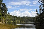
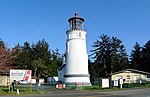
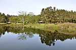
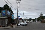
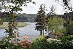
Clear Lake is a natural body of water impounded by sand dunes along the Oregon Coast of the Pacific Ocean in the United States. The lake is the municipal water supply for the city of Reedsport, which lies about 4 miles (6 km) northeast of the lake. Clear Lake is closed to public access to protect the purity of the water.U.S. Route 101 runs north–south along the west side of the lake. The community of Winchester Bay is north of the lake; Umpqua Lighthouse State Park and the mouth of the Umpqua River are to the northwest, and Oregon Dunes National Recreation Area runs along the coast to the west. The outflow from Clear Lake is south to Edna Lake, Clear Creek, and Eel Lake.Clear Lake, at 229 feet (70 m) above sea level, is the highest of several lakes formed by dunes encroaching on Clear Creek's ancestral valley. Water from this string of lakes, including Eel Lake and Tenmile Lake, flows generally south into Tenmile Creek in Coos County, which flows west into the Pacific near the community of Lakeside.
Excerpt from the Wikipedia article Clear Lake (Douglas County, Oregon) (License: CC BY-SA 3.0, Authors, Images).Clear Lake (Douglas County, Oregon)
Geographical coordinates (GPS) Address Nearby Places Show on map
 Continue reading on Wikipedia
 Geographical coordinates (GPS)
| Latitude | Longitude |
|---|---|
| N 43.643611111111 ° | E -124.1825 ° |
Address
Douglas County
Oregon, United States
Open on Google Maps