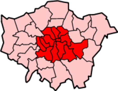
Inner London

Inner London is the name for the group of London boroughs which form the interior part of Greater London and are surrounded by Outer London. With its origins in the bills of mortality, it became fixed as an area for statistics in 1847 and was used as an area of local government from 1855 to 1965 principally as the County of London or earlier as the Metropolitan Board of Works Area (metropolis). It now has two common definitions. The first is the statutory definition delineated in the London Government Act 1963, coming into force on 1 April 1965, comprising twelve Inner London boroughs and almost identical to the County of London that was abolished at the same time. The second is the current definition used by the Office for National Statistics comprising eleven of the statutory Inner London boroughs and two of the statutory Outer London boroughs, and the City of London.Inner London is smaller than Outer London both in terms of population and area, but the density of population is more than double that of Outer London. Inner London is officially the wealthiest area in Europe with the most expensive street in Europe: GDP per capita is more than €80,000 while the UK GDP per capita is around €27,000.
Excerpt from the Wikipedia article Inner London (License: CC BY-SA 3.0, Authors, Images).Inner London
Strand, City of Westminster Covent Garden
Geographical coordinates (GPS) Address Nearby Places Show on map
Geographical coordinates (GPS)
| Latitude | Longitude |
|---|---|
| N 51.508411 ° | E -0.125364 ° |
Address
Charing Cross Station
Strand
WC2R 0QU City of Westminster, Covent Garden
England, United Kingdom
Open on Google Maps


