place

Libbytown

Neighborhoods in Portland, Maine

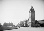
Libbytown is a neighborhood in Portland, Maine, United States. One of the oldest neighborhoods in the city, it is located between the Stroudwater, Rosemont, Oakdale, and Parkside neighborhoods, and is separated from the city of South Portland by the Fore River. It extends to the intersection of Stevens Avenue and Congress Street. It was originally settled by Irish Catholic immigrants. Described as cohesive, it began to decline following the 1961 demolition of Union Station on St. John Street. Around the same time, the neighborhood was divided by the construction of Interstate 295 and the cloverleaf interchange which comprise exit 5. A long-standing Denny's restaurant occupied an area formerly known as Libby's Corner, between Park Avenue to the north and Congress Street to the south. It closed in 2022, and was purchased by the Maine Department of Transportation (MaineDOT). It was demolished in March 2024. MaineDOT plans to construct a roundabout in an attempt to reconnect the neighborhood over sixty years after the division. Park Avenue and Congress Street would return to being two-way streets. The project was given a $22.4 million federal grant as part of the U.S. Department of Transportation's Reconnecting Communities and Neighborhoods Program. Maine's busiest public transit hub, the Portland Transportation Center, is in Libbytown. Tony's Donuts, a donut shop on Bolton Street, was established in the neighborhood in 1965.

Excerpt from the Wikipedia article Libbytown (License: CC BY-SA 3.0, Authors).

Libbytown
Huntress Street, Portland

Geographical coordinates (GPS) Address Nearby Places
placeShow on map

Wikipedia: LibbytownContinue reading on Wikipedia

Geographical coordinates (GPS)

Latitude Longitude
N 43.654033 ° E -70.284836 °
placeShow on map

Address

Huntress Street 15
04102 Portland
Maine, United States
mapOpen on Google Maps

Share experience

Nearby Places

St. John Street (Portland, Maine)

St. John Street is a street in Portland, Maine, United States. It runs for around 1.34 miles (2.16 km) from Brighton Avenue (part of Maine State Route 25), in the north, to Valley Street, in the south. It crosses Park Avenue (part of Maine State Route 22) and Congress Street and passes beneath Interstate 295. Both St. John Street and adjacent Valley Street were built upon land occupied by Portland's poor farm. St. John Street is named for St. John Smith (1876–1944), a landowner friend and business partner of industrialist John Bundy Brown. The city's Union Station stood in Railroad Square on St. John Street between 1888 and 1961, when it was demolished and replaced with today's Union Station Plaza strip mall. Beside that location, to the south, is the Maine Central Railroad General Office Building, which was completed in 1916. It is listed on the National Register of Historic Places. A spur of the Portland and Ogdensburg Railway from Union Station crosses Maine Central Railroad's trestle bridge at St. John Street and Park Avenue. The line continues behind Hadlock Field and Fitzpatrick Stadium before ending at Forest Avenue, beside Deering Oaks Park. The Inn at St. John (formerly the Hotel Victoria), which stands at the intersection of St. John Street and Congress Street, has been in operation since 1897. Its location was chosen because of its proximity to Union Station. St. John Street was the home to Portland's first McDonald's. It is still in operation. Portland's Greyhound bus station was formerly located at the intersection of St. John Street and Congress Street. The building, constructed in 1961, closed in 2019, after 32 years of ownership by Greyhound. Buses now depart from the park and ride lot on Marginal Way.