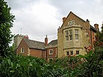
Chosen Hill, Gloucestershire
EngvarB from September 2013Hills of GloucestershireNature reserves in Gloucestershire

Chosen Hill (grid reference SO882187) (or Churchdown Hill) rises above Churchdown in Gloucestershire, England, and is the site of a 11.5-hectare (28-acre) nature reserve.The hill commands good views over the scarp and the Severn Vale and there is a network of paths for walkers. One such path is 'coffin way' from St Bartholomew's Church at the top of the hill towards Hucclecote.Covered reservoirs were constructed on the Hill in the 1940s and 1950s. There is an archaeological site - an Iron Age fort known as Churchdown Hill Camp - below the main reservoir.Geologically, it is on one of outliers of the Cotswold scarp.
Excerpt from the Wikipedia article Chosen Hill, Gloucestershire (License: CC BY-SA 3.0, Authors, Images).Chosen Hill, Gloucestershire
Geographical coordinates (GPS) Address Nearby Places Show on map
Geographical coordinates (GPS)
| Latitude | Longitude |
|---|---|
| N 51.867202777778 ° | E -2.1720527777778 ° |
Address
GL3 2LG , Churchdown
England, United Kingdom
Open on Google Maps


