place

Terminal Storage Warehouse District
Boston Registered Historic Place stubsBoston building and structure stubsBuildings and structures in BostonCharlestown, BostonCommercial buildings on the National Register of Historic Places in Massachusetts
Historic districts on the National Register of Historic Places in MassachusettsNRHP infobox with nocatNational Register of Historic Places in BostonWarehouse districts of the United StatesWarehouses on the National Register of Historic Places
BostonMA TerminalStorageWarehouseDistrict

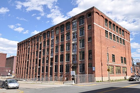
The Terminal Storage Warehouse District is located at Medford and Terminal Streets in the Charlestown neighborhood of Boston, Massachusetts. It includes three large brick warehouse buildings which were built between 1910 and 1913. They are rare surviving elements of the commercial development of the Charlestown waterfront early in the 20th century. They were built by two separate companies which had common ownership. The buildings at 40 and 50 Terminal Street were built by the Terminal Wharf & Railroad Warehouse Company, and that at 267-281 Medford Street was built by the Terminal Storage Warehouse Company. They were built to serve as storage facilities for the transhipment by rail and ship of goods through the port. The buildings were vacated in 1984, and are being rehabilitated after many years of vacancy.In 2014, the warehouse at 267-281 Medford Street was renovated into apartments after a 17-year-long legal battle related to the building's location in the Terminal Storage Warehouse District and its proximity to the waterfront. During the renovations, much of the original longleaf pine decking of the building was salvaged and recycled.The district was listed on the National Register of Historic Places on March 12, 2012.

Excerpt from the Wikipedia article Terminal Storage Warehouse District (License: CC BY-SA 3.0, Authors, Images).

Terminal Storage Warehouse District
Medford Street, Boston Charlestown

Geographical coordinates (GPS) Address Nearby Places
placeShow on map

Wikipedia: Terminal Storage Warehouse DistrictContinue reading on Wikipedia

Geographical coordinates (GPS)

Latitude Longitude
N 42.380833333333 ° E -71.061666666667 °
placeShow on map

Address

Medford Street 260;262
02129 Boston, Charlestown
Massachusetts, United States
mapOpen on Google Maps

BostonMA TerminalStorageWarehouseDistrict
Share experience

Nearby Places

Charlestown Heights
Charlestown Heights

Charlestown Heights, also known as the Doherty Playground or Doherty Park, is an urban park in Charlestown, a neighborhood of Boston, Massachusetts. It is one of five small urban parks designed by Frederick Law Olmsted for the city. These small parks were designed to provide small greenspaces in densely populated neighborhoods. The Doherty Playground was laid out on the north side of Bunker Hill, sloping down the hill from Bunker Hill Avenue to Medford Street, between St. Martin Street and North Mead Street.The park was laid out in the early 1890s and opened in 1895. It is divided into three sections. The uppermost section, abutting Bunker Hill Avenue, is essentially a flat promenade, a grassy area dotted with trees, with paths and benches, as well as a monument commemorating the 1775 Battle of Bunker Hill. An allée of trees line runs parallel to the street.A large central area of the park contains active recreation facilities, and is the portion of the park which has been most altered from the original Olmsted design. It includes the Clougherty Pool complex, including a swimming pool and Moderne-style bathhouse designed by John M. Gray. This level also includes basketball courts, a playground, and a wading pool. The lowest level of the park, abutting Medford Street, is a sloping meadow with naturalistic pathways meandering through it. Stairs in this section have granite rises, with cheeks of puddingstone.The park was listed on the National Register of Historic Places in 1998.

Charlestown, Boston
Charlestown, Boston

Charlestown is the oldest neighborhood in Boston, Massachusetts, in the United States. Originally called Mishawum by the Massachusett tribe, it is located on a peninsula north of the Charles River, across from downtown Boston, and also adjoins the Mystic River and Boston Harbor waterways. Charlestown was laid out in 1629 by engineer Thomas Graves, one of its earliest settlers, in the reign of Charles I of England. It was originally a separate town and the first capital of the Massachusetts Bay Colony. Charlestown became a city in 1848 and was annexed by Boston on January 5, 1874. With that, it also switched from Middlesex County, to which it had belonged since 1643, to Suffolk County. It has had a substantial Irish-American population since the migration of Irish people during the Great Irish Famine of the 1840s. Since the late 1980s, the neighborhood has changed dramatically because of its proximity to downtown and its colonial architecture. A mix of yuppie and upper-middle-class gentrification has influenced much of the area, as it has in many of Boston's neighborhoods, but Charlestown still maintains a strong Irish-American population. In the 21st century, Charlestown's diversity has expanded dramatically, along with growing rates of the very poor and very wealthy. Today Charlestown is a largely residential neighborhood, with much housing near the waterfront, overlooking the Boston skyline. Charlestown is home to many historic sites, hospitals and organizations, with access from the Orange Line Sullivan Square or Community College stops or the I-93 expressway.