place

Tromode

Isle of Man geography stubsVague or ambiguous time from August 2012Villages in the Isle of Man

Tromode is a village in Braddan parish, Isle of Man. It is on the boundary with and partly within the borough of Douglas, and is within the Douglas conurbation. During the period of Manx nationalism, Ny Troor Tromode ("The Tromode Three") committed acts of arson and vandalism on the island.

Excerpt from the Wikipedia article Tromode (License: CC BY-SA 3.0, Authors).

Tromode
Dreeym Beary, Douglas Willaston

Geographical coordinates (GPS) Address Nearby Places
placeShow on map

Wikipedia: TromodeContinue reading on Wikipedia

Geographical coordinates (GPS)

Latitude Longitude
N 54.168 ° E -4.49 °
placeShow on map

Address

Dreeym Beary

Dreeym Beary
Douglas, Willaston
Isle of Man
mapOpen on Google Maps

Share experience

Nearby Places

Bray Hill
Bray Hill

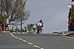
Bray Hill (Lowland Scots: Brae a slope) is a road in the Isle of Man. It was formerly a country lane known as the Great Hill during the time of the ownership of the Duke of Atholl, and was previously known as Siberia, originally a triangle-shaped parcel of land in the Murray Estate.Bray Hill is a steep downhill section of the TT course situated between the TT Grandstand and the 1st Milestone road-side marker on the Snaefell Mountain Course on the primary the A2 Douglas to Ramsey road in the town of Douglas in the Isle of Man.The Bray Hill section runs from St Ninian's Crossroads, where the A2 Glencrutchery Road (from the TT startline) meets the side streets of Ballanard Road and Ballaquayle Road on the A22, continuing to the base of the hill where it becomes the A2 Quarterbridge Road at a crossroad-junction with side streets named Tromode Road, Stoney Road, and Thorny Road. Bray Hill was part of the Highland Course and Four Inch Course used for the Gordon Bennett Trial and Tourist Trophy car races held between 1904 and 1922. For the 1934 and 1935 car races, the whole length of Bray Hill from its junction with Stoney Road was part of the Mannin Moar Course. The startline and refuelling area for the Isle of Man TT races was situated at the top of Bray Hill for the 1914 TT races, moving in 1920 to the Nobles Park area of the A2 Glencrutchery Road. Bray Hill is part of the Snaefell Mountain Course used since 1911 for the TT races and Manx Grand Prix since 1923. The A2 Bray Hill and A2 Quarterbridge Road were subjected to major road repairs and re-profiling during the winter of 1978/79 by the Isle of Man Highway Board. This followed two fatal accidents at the start of the 1978 Sidecar TT 'A' race involving sidecar crew of Mac Hobson/Kenny Birch on Bray Hill and Swiss sidecar competitor Ernst Trachsel on nearby Quarterbridge Road.In 2013, a rider lost control on the first lap of the Senior TT and his machine impacted with spectators near to the bottom of the hill, close to the junction, injuring eleven.

St Ninian's Crossroads

St Ninian's Crossroads (Manx: Ballaquayle, Quayle, or MacFayle's farm - the quarterland of Ballaquayle) is situated between the TT Grandstand and the 1st Milestone road-side marker on the Snaefell Mountain Course on the primary A2 Douglas to Ramsey road in the town of Douglas in the Isle of Man.The St. Ninian's Crossroads is a major road junction of the A2 Glencrutchery Road with the A2 Bray Hill, the A22 Ballanard Road and Ballaquayle Road in Douglas. The area is dominated by St. Ninian's Church (dedicated to Ninian of Whithorn) designed by W.D.Caroe and is a major landmark on the skyline of the town of Douglas. The land to build the church in 1913 was bequeathed by Henry Bloom Noble through trustees of his estate. In 1924, the Douglas High School for Boys was constructed on a nearby site by the Isle of Man Education Board and is now the coeducational St Ninian's High School (Schoill Ard Noo Ninian). The crossroads at St. Ninian's was part of the Highland Course and Four Inch Course used for the Gordon Bennett Trial and Tourist Trophy car races held between 1904 and 1922. The St. Ninian's Crossroads road is part of the Snaefell Mountain Course used since 1911 for the Isle of Man TT races and the Manx Grand Prix since 1923. During the 1914 Junior TT race, Frank Walker's view of the A23 Ballanard Road was obscured by spectators who had encroached onto the road to watch the competitors. Passing the Judges-Box at the finish-line, Walker continued at full racing speed through St. Ninians Crossroads, collided with a wooden barrier in Ballaquayle Road, was thrown from his motorcycle and later died of his injuries at nearby Nobles Hospital. The St Ninian's Crossroads as Parkfield Corner was part of the Clypse Course used between 1954 and 1959 for the Isle of Man TT and for the Manx Classic Races as part of the Willaston Circuit between 1988 and 2000. In 1971 the first permanent site of traffic light signals in the Isle of Man were installed at St.Ninian's crossroads. Part of the road junction with Ballaquayle Road and St Ninian's church was widened and re-profiled in 2007 by the Isle of Man Department of Transport.