place

Řeporyje

Districts of PraguePrague geography stubs
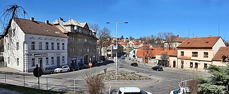
Řeporyjské náměstí celek

Řeporyje is a cadastral area of Prague. Most of it belongs to the municipal district of the same name, the rest belonging to Prague 13. Řeporyje became part of Prague in 1974, before which it was recorded as a městys. The district is situated on Dalejský potok and borders Prokopské údolí to the east. The western part of Řeporyje is an industrial area, marked by the visually prominent silo belonging to Soufflet Agro a.s. The district is served by Praha-Řeporyje railway station, a passing point on the Praha – Rudná – Beroun railway line.

Excerpt from the Wikipedia article Řeporyje (License: CC BY-SA 3.0, Authors, Images).

Řeporyje
Řeporyjské náměstí, Prague Řeporyje

Geographical coordinates (GPS) Address Nearby Places
placeShow on map

Wikipedia: ŘeporyjeContinue reading on Wikipedia

Geographical coordinates (GPS)

Latitude Longitude
N 50.033055555556 ° E 14.311666666667 °
placeShow on map

Address

Řeporyjské náměstí 16
155 00 Prague, Řeporyje
Prague, Czechia
mapOpen on Google Maps

Řeporyjské náměstí celek
Share experience

Nearby Places

Stodůlky
Stodůlky

Stodůlky, Czech pronunciation: [ˈstoduːlkɪ], is a cadastral area (katastrální území) in Prague, Czech Republic. Originally a village (first written mention of which dates from 1159), later municipality (since 1849), it remained a predominantly agricultural settlement until the 1960s. Stodůlky became part of Prague in 1974 and the large housing estate of Jihozápadní Město gradually arose on fields in vicinity of the old village in the late 1970s through mid-1990s. Nowadays Stodůlky covers an area of 9.63 square kilometres (3.72 sq mi) and has over 60 thousand inhabitants (these figures account for approximately 1/50 of territory and 1/40 of Greater Prague population). Západní Město, a western extension of the built-up area is currently (as of 2011) under construction. The name derives from the Czech noun stodola for barn; Stodůlky is then a pluralized diminutive of that word (i.e. meaning "small barns"). Stodůlky is located at the southwestern outskirts of the city, about 9 kilometres (6 mi) from the centre. It borders cadastral areas of Řepy in the north, Motol in the northeast, Jinonice in the east, Holyně and Řeporyje in the south, Třebonice in the west and Zličín in the northwest. As a whole it belongs to Praha 5 territorial district. For administrative purposes the vast majority of Stodůlky is designated as an administrative district of Praha 13, while a small section of it falls under Praha-Řeporyje. Stodůlky is served by Line B of the Prague Metro with five stations being located on its territory (each station in general bears the name of the corresponding housing subdistrict). The stations are (in direction from city centre): Nové Butovice Hůrka Lužiny Luka Stodůlky