place

Bloody Point, South Carolina

Unincorporated communities in Beaufort County, South CarolinaUnincorporated communities in South CarolinaUse mdy dates from July 2023

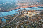
Bloody Point is a residential community on the southernmost tip of Daufuskie Island, South Carolina, United States. It is bordered by the Atlantic Ocean on one side and Mungen River on the other.

Excerpt from the Wikipedia article Bloody Point, South Carolina (License: CC BY-SA 3.0, Authors).

Bloody Point, South Carolina
Bloody Point Drive,

Geographical coordinates (GPS) Address Nearby Places
placeShow on map

Wikipedia: Bloody Point, South CarolinaContinue reading on Wikipedia

Geographical coordinates (GPS)

Latitude Longitude
N 32.09181 ° E -80.872507 °
placeShow on map

Address

Bloody Point

Bloody Point Drive
29915
South Carolina, United States
mapOpen on Google Maps

Share experience

Nearby Places

Siege of Fort Pulaski

The siege of Fort Pulaski (or the Siege and Reduction of Fort Pulaski) concluded with the Battle of Fort Pulaski fought April 10–11, 1862, during the American Civil War. Union forces on Tybee Island and naval operations conducted a 112-day siege, then captured the Confederate-held Fort Pulaski after a 30-hour bombardment. The siege and battle are important for innovative use of rifled guns which made existing coastal defenses obsolete. The Union initiated large-scale amphibious operations under fire. The fort's surrender strategically closed Savannah as a port. The Union extended its blockade and aids to navigation down the Atlantic coast, then redeployed most of its 10,000 troops. The Confederate army-navy defense blocked Federal advance for over three months, secured the city, and prevented any subsequent Union advance from seaward during the war. Coastal rail connections were extended to blockaded Charleston, South Carolina. Fort Pulaski is located on Cockspur Island, Georgia, near the mouth of the Savannah River. The fort commanded seaward approaches to the City of Savannah. The city was commercially and industrially important as a cotton exporting port, railroad center and the largest manufacturing center in the state, including a state arsenal and private shipyards. Two southerly estuaries led to the Savannah River behind the fort. Immediately east of Pulaski, and in sight of Hilton Head Island, South Carolina, lay Tybee Island with a lighthouse station.

Stoney-Baynard Plantation

Stoney-Baynard Plantation on Hilton Head Island, SC was listed on the National Register of Historic Places in 1994. The listing included one contributing site on 6 acres (2.4 ha).It has also been known as Baynard Ruins and as Braddock's Point Plantation. The historic site and ruins are located in between Baynard Park Road and Plantation Drive within present day Sea Pines Plantation, a private gated community on the south end of Hilton Head Island, South Carolina. The site consists of below ground archaeological remains covering an area just under six acres and a series of four ruins. A main house, an overseer's house, and a slave house are associated with the Stoney-Baynard Plantation, dating from the first decade of the nineteenth century. A fourth structure was associated with the site's occupation by Union pickets after the Battle of Port Royal during the Civil War. The archaeological remains are well preserved, with archaeological testing documenting intact sub-surface features and clear horizontal patterning of artifacts. Standing architectural ruins include 2-story portions of the main house, a chimney footing for the overseer's house, and footings for a tent for the Union Troops. The structures were built in the Georgian Architectural style with tabby foundations and exterior walls. Today the site is incorporated into green spaced land owned by the Sea Pines Community Services Administration Association and is consequently preserved.