place

Siege of Fort Pulaski

1862 in Georgia (U.S. state)1862 in the American Civil WarApril 1862 eventsBattles of the Lower Seaboard Theater and Gulf Approach of the American Civil WarChatham County, Georgia
Military operations of the American Civil War in Georgia (U.S. state)Union victories of the American Civil War
Fort Pulaski Under Fire April 1862 Leslie s Weekly Mod

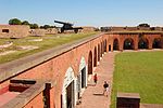
The siege of Fort Pulaski (or the Siege and Reduction of Fort Pulaski) concluded with the Battle of Fort Pulaski fought April 10–11, 1862, during the American Civil War. Union forces on Tybee Island and naval operations conducted a 112-day siege, then captured the Confederate-held Fort Pulaski after a 30-hour bombardment. The siege and battle are important for innovative use of rifled guns which made existing coastal defenses obsolete. The Union initiated large-scale amphibious operations under fire. The fort's surrender strategically closed Savannah as a port. The Union extended its blockade and aids to navigation down the Atlantic coast, then redeployed most of its 10,000 troops. The Confederate army-navy defense blocked Federal advance for over three months, secured the city, and prevented any subsequent Union advance from seaward during the war. Coastal rail connections were extended to blockaded Charleston, South Carolina. Fort Pulaski is located on Cockspur Island, Georgia, near the mouth of the Savannah River. The fort commanded seaward approaches to the City of Savannah. The city was commercially and industrially important as a cotton exporting port, railroad center and the largest manufacturing center in the state, including a state arsenal and private shipyards. Two southerly estuaries led to the Savannah River behind the fort. Immediately east of Pulaski, and in sight of Hilton Head Island, South Carolina, lay Tybee Island with a lighthouse station.

Excerpt from the Wikipedia article Siege of Fort Pulaski (License: CC BY-SA 3.0, Authors, Images).

Siege of Fort Pulaski
Fort Perimeter Trail,

Geographical coordinates (GPS) Address Nearby Places
placeShow on map

Wikipedia: Siege of Fort PulaskiContinue reading on Wikipedia

Geographical coordinates (GPS)

Latitude Longitude
N 32.02729 ° E -80.89096 °
placeShow on map

Address

Fort Pulaski

Fort Perimeter Trail
31328
Georgia, United States
mapOpen on Google Maps

Fort Pulaski Under Fire April 1862 Leslie s Weekly Mod
Share experience

Nearby Places

Tybee Island, Georgia

Tybee Island is a city and a barrier island in Chatham County, Georgia, 18 miles (29 km) east of Savannah. The name "Tybee Island" is used for both the island and the city, but geographically they are not identical: only part of the island's territory lies within the city. The island is Georgia's easternmost point. The phrase "From Rabun Gap to Tybee Light", intended to illustrate Georgia's geographic diversity, contrasts a mountain pass near the state's northernmost point with the coastal island's lighthouse. As of the 2020 census, the city's population was 3,114. The entire island is a part of the Savannah metropolitan statistical area. Officially renamed Savannah Beach in a publicity move at the end of the 1950s, the city of Tybee Island has since reverted to its original name. (The name Savannah Beach nevertheless appears on official state maps as far back as 1952 and as recently as the mid-1970s.) The small island, which has long been a quiet beach getaway for Savannah residents, has become a popular vacation spot for tourists from outside the Savannah area. Tybee Island is home to the first of what eventually became the Days Inn chain of hotels, the oft-photographed Tybee Island Light Station, and the Fort Screven Historic District. The U.S. Air Force accidentally dropped an atomic bomb into the sea off Tybee Island during a botched 1958 military training exercise. Though the "Tybee Bomb" did not detonate (according to some reports, it was never armed with a fuse), there has been ongoing concern because the Mark 15 nuclear bomb lost during the mishap was never recovered.

Dutton–Waller Raised Tybee Cottage

Dutton–Waller Raised Tybee Cottage is a cottage on Tybee Island, Georgia, in Chatham County, Georgia, near Savannah. It is significant as a very well preserved example of a raised Tybee cottage. It is one of few still intact from the "golden era" of Tybee Island's development during 1910–1939, when Tybee Island became a beach house community for Savannah middle-class families.It was listed on the National Register of Historic Places on July 24, 2008. It is the fourth property that is listed as a featured property of the week in a program of the National Park Service that began in July 2008.The cottage is located in the Back River area of Tybee Island; there are also historic cottages preserved in the Strand area of the island. Cottages of this type were built from the 1920s through the 1940s as summer homes for the middle class. The Dutton–Waller Raised Tybee Cottage was built as a speculative investment by Edward A. Dutton in 1938. It was purchased in 1940 by Blanche S. Waller. The unpainted interior retains the original, rustic heart-pine paneling and bungalow floor plan. The living space is on the upper floor of the two-story building, with servants' quarters and garage space below. The cottage was remodeled extensively in 2006. It has been refurbished to remove non-historic changes made in the 1950s–1970s and replace historic elements that had been removed. The cottage's significance is enhanced by the fact that it is one of the few such cottages remaining, most having been demolished to make way for much bigger homes in recent times of escalating property values. It is listed as a three-bedroom, two-bathroom home, with an additional sleeping porch. There are live oak trees, jasmine, and palm trees surrounding the house.