place

Bickleigh Castle

All accuracy disputesCastles in DevonCountry houses in DevonGrade I listed buildings in Devon
Bickleigh castle
Bickleigh castle

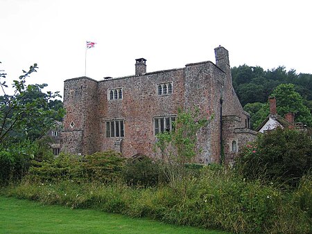
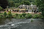
Bickleigh Castle is a fortified manor house that stands on the banks of the River Exe at Bickleigh in Devon, England. Once considerably larger, Bickleigh now comprises a group of buildings from various periods which together formed a water castle. The main building was destroyed during the English Civil War, however other buildings, mostly arranged around a central courtyard survived. The castle is frequently open to the public by appointment, but it serves principally as a wedding venue. The River Exe runs through the grounds.

Excerpt from the Wikipedia article Bickleigh Castle (License: CC BY-SA 3.0, Authors, Images).

Bickleigh Castle
A3072, Mid Devon Bickleigh

Geographical coordinates (GPS) Address External links Nearby Places
placeShow on map

Wikipedia: Bickleigh CastleContinue reading on Wikipedia

Geographical coordinates (GPS)

Latitude Longitude
N 50.851388888889 ° E -3.5125 °
placeShow on map

Address

Bickleigh Castle

A3072
EX16 8RS Mid Devon, Bickleigh
England, United Kingdom
mapOpen on Google Maps

linkWikiData (Q4903673)
linkOpenStreetMap (205506104)

Bickleigh castle
Bickleigh castle
Share experience

Nearby Places

Silverton, Devon
Silverton, Devon

Silverton is a large village and civil parish, about 8 miles (13 km) north of Exeter, in the English county of Devon. It is one of the oldest villages in Devon and dates from the first years of the Saxon occupation.It has been suggested that the medieval manor of Burn, within the modern parish of Silverton, may be the estate listed as Mylenburnan (Mill-on-the-Burn or Burn Mill) in the will of King Alfred the Great of 899, now in the British Library, in which it was left to his youngest son Athelweard (c. 880-922). In the year 2001, its population was 1,905, recounted to 1,494 at the United Kingdom Census 2011. The electoral ward with the same name had a population of 1,875 at the above census. The parish has two pubs: The Lamb and The Silverton Inn. The church, dating back to the fourteenth century, is dedicated to St Mary. It has a full set of bells that are rung regularly. Inside, the pews have doors at the end of each row which is unusual in this area. The village also has a further two churches - an Evangelical and a Methodist church; both are popular with social and youth clubs. The village is on the "old" road from Exeter to Tiverton and as such was once a busy thriving place. Now it has become a dormitory for people working in Exeter although there are still a number of original families living in the village. A post office, a small supermarket (Spar) and a hairdresser offer most necessities for the residents. The main feature of the village is the giant oak tree which is over 1,000 years old.On the first Saturday of each August, the village holds the Silverton Street Market, which is popular amongst both local people and many from across Devon and the South West. There are stalls selling local goods and crafts, as well as entertainment and children's activities organised throughout the day, and the tug-of-war always ends the day on a high. Silverton is represented on Mid Devon District Council by Liberal Democratic Party Councillor Josh Wright (Village Ward) and by Conservative Councillor Rhys Roberts (North Ward). The Bristol and Exeter Railway opened a Station at Silverton in 1867, it closed to passengers on 5 October 1964 and freight 3 May 1965, but a private siding serving a paper mill, which had been opened on 26 July 1894, survived until the 31 August 1967. The Station Master from its opening until 1894 was one Roger Langdon (1825-1894), a noted amateur astronomer. Following the partial solar eclipse of 22 December 1870 Langdon altered his telescope to view a solar prominence. He also observed the planet Venus including the transit of 1882. A summary of his life was published by Patrick Moore.
Cranmore Castle
Cranmore Castle

Cranmore Castle is an Iron Age earthwork situated on a hillside above the Devon town of Tiverton in south-west England. Its National Grid reference is SS958118. It is an English Heritage scheduled monument, and has been given a National Monument number of 34256. The earthwork is widely described in guidebooks and histories as an Iron Age hill fort though more recent archaeological evaluations and histories, such as Mike Sampson's recently published work, point out that it seems inefficient as a fortification, since it is overlooked from the south by the higher slope of Exeter Hill/Newtes Hill. The earthwork is also unusual in that the area it encloses slopes from 120 metres (390 ft) to 170 metres (560 ft) above sea level. This arrangement does however offer clear lines of sight to Cadbury Castle, Castle Close below Stoodleigh up the Exe Valley, Huntsham Castle, Hembury fort and other significant hills and earthworks, suggesting that all were contemporary. It also manages to overlook the confluence of the rivers Lowman and Exe and the forded crossings on those rivers, which a higher position would not allow. The hillside that Cranmore Castle stands above is called Skrink Hills or Shrink Hills in various early histories of the area. and it is from there that Thomas Fairfax's artillery laid siege to Tiverton Castle. The promontory of land that links Cranmore to the edge of Newtes Hill is traversed by the old Exeter Road, which travels past the earthwork on its way from Tiverton to Exeter. The hill and road have latterly been known as Exeter Hill, and this road almost certainly follows the path of a prehistoric trackway. Current theories about the nature of the earthwork suggest that it might have been a winter enclosure for livestock or a market site, though the earthworks are very substantial for such applications and could even point to a tribal oppidum. Certainly the area would be large enough. The Ordnance Survey Map of Southern Britain in the Iron Age shows Cranmore as the largest enclosure in Devon (along with Hillsborough) at over 15 acres (61,000 m2). During the Prayer Book Rebellion of 1549 Cranmore Castle became the site of a fierce battle fought between the two sides over whether a child should be baptised according to the 'new' religion or the 'old'. The battle took place near a small chapel that stood at one corner of the site, near the road. The chapel was demolished in the 17th century, and in 1687 bones and musket shots thought to be from the battle were discovered.The etymology of the name Cranmore Castle is unclear. Cranmore is not a local name and does not fit with any local placenames. No record of Cranmore seems to exist in any early records. It is possible that the name is derived from the battle described above. The archbishop at the time of the Prayer Book Rebellion was Thomas Cranmer so it is possible it derives from a variation of 'Cranmer Castle' in reference to the battle fought there.