place

Koblenz-Lützel station

Railway stations in Germany opened in 1858Railway stations in Koblenz
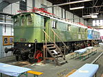
Bahnhof Koblenz Lützel 2010

Koblenz-Lützel station is the oldest still-operating station in the city of Koblenz in the German state of Rhineland-Palatinate. It was built at the same time as the Koblenz Rhenish station (German: Rheinischer Bahnhof), which was abandoned in 1902 with the opening of the Koblenz Central Station (Hautptbahnhof) and destroyed in World War II. The station is located in the Koblenz suburb of Lützel, near the Moselle river and the Moselle railway bridge. It includes a passenger station and a freight yard. There was also a freight wagon repair shop, which is now closed and is now the site of the DB Museum, Koblenz. The now dismantled Koblenz-Lützel–Mayen Ost railway branched off the West Rhine Railway (the left bank line, German: Linke Rheinstrecke) in Koblenz-Lützel from 1904 to 2003. The Neuwied–Koblenz railway was built to connect the East Rhine Railway (the right bank line, Rechte Rheinstrecke) to the left bank line and the Moselle line, which is important for freight traffic, at Koblenz-Lützel station. Koblenz has had three stations in two kilometres on the left bank line with Koblenz-Lützel station, Koblenz Central Station and Koblenz City Centre Station (Koblenz Stadtmitte), completed of in 2011.

Excerpt from the Wikipedia article Koblenz-Lützel station (License: CC BY-SA 3.0, Authors, Images).

Koblenz-Lützel station
Mayener Straße, Koblenz Lützel

Geographical coordinates (GPS) Address Nearby Places
placeShow on map

Wikipedia: Koblenz-Lützel stationContinue reading on Wikipedia

Geographical coordinates (GPS)

Latitude Longitude
N 50.367777777778 ° E 7.5916666666667 °
placeShow on map

Address

Koblenz-Lützel Gleis 3 / 4

Mayener Straße
56070 Koblenz, Lützel
Rhineland-Palatinate, Germany
mapOpen on Google Maps

Bahnhof Koblenz Lützel 2010
Share experience

Nearby Places

Rhine Province
Rhine Province

The Rhine Province (German: Rheinprovinz), also known as Rhenish Prussia (Rheinpreußen) or synonymous with the Rhineland (Rheinland), was the westernmost province of the Kingdom of Prussia and the Free State of Prussia, within the German Reich, from 1822 to 1946. It was created from the provinces of the Lower Rhine and Jülich-Cleves-Berg. Its capital was Koblenz and in 1939 it had 8 million inhabitants. The Province of Hohenzollern was militarily associated with the Oberpräsident of the Rhine Province. The Rhine Province was bounded on the north by the Netherlands, on the east by the Prussian provinces of Westphalia and Hesse-Nassau, and the grand duchy of Hesse-Darmstadt, on the southeast by the Palatinate (a district of the Kingdom of Bavaria), on the south and southwest by Lorraine, and on the west by Luxembourg, Belgium and the Netherlands. The small exclave district of Wetzlar, wedged between the grand duchy states Hesse-Nassau and Hesse-Darmstadt was also part of the Rhine Province. The principality of Birkenfeld, on the other hand, was an enclave of the Grand Duchy of Oldenburg, a separate state of the German Empire. In 1911, the extent of the province was 10,423 km2 (4,024 sq mi); its extreme length, from north to south, was nearly 200 km (120 mi), and its greatest breadth was just under 90 km (56 mi). It included about 200 km (120 mi) of the course of the Rhine, which formed the eastern border of the province from Bingen to Koblenz, and then flows in a north-northwesterly direction inside the province, approximately following its eastern border. It is now part of North Rhine-Westphalia, Rhineland-Palatinate, Saarland, and Hesse.