place

Sheffield station

1870 establishments in EnglandCharles Trubshaw railway stationsDfT Category B stationsFormer Midland Railway stationsGrade II listed buildings in Sheffield
Incomplete lists from September 2017John Holloway Sanders railway stationsNorthern franchise railway stationsPages with no open date in Infobox stationRailway stations in Great Britain opened in 1870Railway stations in SheffieldRailway stations served by CrossCountryRailway stations served by East Midlands RailwayRailway stations served by TransPennine ExpressSheffield Supertram stopsUse British English from March 2015
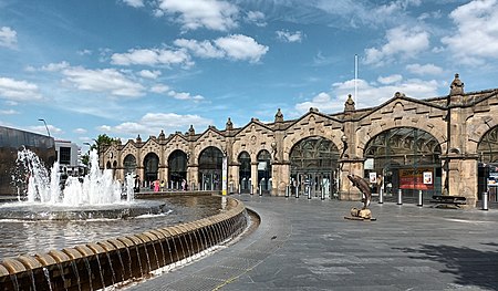
Sheffield Station 2022

Sheffield station, formerly Pond Street and later Sheffield Midland, is a combined railway station and tram stop in Sheffield, England; it is the busiest station in South Yorkshire. Adjacent is Sheffield station/Sheffield Hallam University Sheffield Supertram stop. In 2017–18, the station was the 43rd-busiest in the UK and the 15th-busiest outside London.

Excerpt from the Wikipedia article Sheffield station (License: CC BY-SA 3.0, Authors, Images).

Sheffield station
Granville Street, Sheffield Park Hill

Geographical coordinates (GPS) Address Nearby Places
placeShow on map

Wikipedia: Sheffield stationContinue reading on Wikipedia

Geographical coordinates (GPS)

Latitude Longitude
N 53.378 ° E -1.462 °
placeShow on map

Address

Sheffield

Granville Street
S1 2BP Sheffield, Park Hill
England, United Kingdom
mapOpen on Google Maps

Sheffield Station 2022
Share experience

Nearby Places

Sheaf Square
Sheaf Square

Sheaf Square is a municipal square lying immediately east of the city centre of Sheffield, England. The sides of the square are lined with major buildings: Sheffield railway station, the Showroom Cinema, Sheffield Science Park, the early nineteenth century Howard Hotel, in addition to the site of the old Nelson Mandela Building, the former Sheffield Hallam University Students' Union, demolished to make way for a proposed mixed-use development, by CTP St. James, incorporating office and hotel space. Sheaf House and Dyson House, demolished in 2005 and 2006 respectively, completed the square, which now has its southern edge much further back, lined by the station's car-park. Plans include further development of the Sheffield Digital Campus, and an addition to the Transport Interchange on the site of Sheaf House. The square lies near the confluence of the Porter Brook and River Sheaf. Pond Tilt Forge and its dam were constructed on the site in 1732, with Bamforth Dam following about 1780. The two were filled in 1856 to accommodate the proposed railway station. The square was built as part of the Corporation's post-World War II traffic plan for Sheffield. The site became a major intersection on Sheffield's new inner ring road with Sheaf Street, Pond Street, Howard Street and Paternoster Row meeting at a roundabout which was named Sheaf Square after the now subterranean river. Work began in 2006 to simplify the road system and create a primarily pedestrianised space with a water cascade and a steel sculpture, leading people from the station, up Howard Street and into the city centre to the side of the Square. The gateway to Sheffield city centre situated to the side of Sheaf Square opened on 22 December 2006 with street performances and a fireworks display. The gateway contains seating, trees, effective lighting and two large water features, one of which includes The Cutting Edge steel sculpture. The new construction now acts as a 21st-century gateway to the city and aims to give a good first impression of Sheffield to those arriving by train. The maps below show the difference in the road layout of Sheaf Square before and after the remodelling:

Cholera Monument Grounds and Clay Wood

The Cholera Monument is a memorial in Sheffield, England, to the victims of a cholera epidemic of 1832. Of the 402 victims of the disease 339 were buried in grounds between Park Hill and Norfolk Park adjoining Clay Wood. Money from the treasurers of the Board of Health was set aside for a monument for the site. The monument was designed by M. E. Hadfield, sculpted by Earp and Hobbs and completed in 1835. It is a neo-Gothic pinnacle and has a plaque naming John Blake, Master Cutler in 1832 and a victim of the epidemic and noting that the foundation stone was laid by the poet James Montgomery. The monument is situated in gardens laid out around the monument in the 1850s and next to Clay Wood, an ancient woodland. These were given to the city by the Duke of Norfolk in 1930. A shaded path laid between 1971 and 1995 traverses the woods from Fitzwalter Road to the monument gardens. The monument was struck by lightning in 1990 and the top removed for safety. Rebuilding began in 2005 thanks to a grant, and was completed in 2006. Restorer Jim Hurley and his team received the 2006 Marsh Award for Excellence in Public Sculpture for their work.A clay cobbled mound art installation was erected in 2004, representing the individuals who died. September 2014 saw the official opening of a 'green link', providing paths and cycle ways between Norfolk Heritage Park and the city centre. The route included the Cholera Monument Grounds, opening up the north-western corner of the grounds which overlook the city centre, and providing a direct link from the monument to Shrewsbury Road. The monument is grade II listed, while the grounds are a conservation area which has received a Green Flag Award.