place

Bromholm Priory

1113 establishments in England1536 disestablishments in EnglandChristian monasteries established in the 12th centuryCluniac monasteries in EnglandGrade I listed buildings in Norfolk
Monasteries in NorfolkNorfolk building and structure stubsReligious organizations established in the 1110sUnited Kingdom Christian monastery stubs
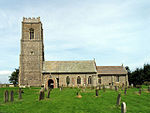
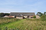
Broomholm Priory geograph.org.uk 775704

Bromholm Priory was a Cluniac priory, situated in a coastal location near the village of Bacton, Norfolk, England

Excerpt from the Wikipedia article Bromholm Priory (License: CC BY-SA 3.0, Authors, Images).

Bromholm Priory
Priory Road, North Norfolk Bacton

Geographical coordinates (GPS) Address Nearby Places
placeShow on map

Wikipedia: Bromholm PrioryContinue reading on Wikipedia

Geographical coordinates (GPS)

Latitude Longitude
N 52.844479 ° E 1.487463 °
placeShow on map

Address

Priory Road

Priory Road
NR12 0HQ North Norfolk, Bacton
England, United Kingdom
mapOpen on Google Maps

Broomholm Priory geograph.org.uk 775704
Share experience

Nearby Places

Bacton, Norfolk
Bacton, Norfolk

Bacton is a village and civil parish in Norfolk, England. It is on the Norfolk coast, some 12 miles (20 km) south-east of Cromer, 25 miles (40 km) north-west of Great Yarmouth and 19 miles (30 km) north of Norwich. Besides the village of Bacton, the parish includes the nearby settlements of Bacton Green, Broomholm, Keswick and Pollard Street. It also includes Edingthorpe, which was added to Bacton civil parish under the County of Norfolk Review Order, 1935. The seaside village, whose name is derived from 'Bacca's farm/settlement', is located on the North Norfolk coast between Mundesley (a blue flag beach) and Walcott, Norfolk. Bacton is known for its very quiet sandy beaches offering miles of walking along the beach and cliffs. The England Coast Path passes through the village and also the Paston Way long-distance footpath linking Cromer and North Walsham. In the east of the parish can be found the ruined Cluniac Bromholm Priory. The civil parish has an area of 9.45 square kilometres (3.65 sq mi) and in the 2001 census had a population of 1,130 in 474 households the population increasing to 1,194 at the 2011 Census. For the purposes of local government, the parish falls within the district of North Norfolk. Amenities in the village include: a village shop, a hotel, two cafes, a Chinese restaurant and kebab house, as well as a recreation ground. In addition there are several caravan parks and estates consisting of privately owned holiday chalets, giving holidaymakers access to the beach. During the First World War there was also an airfield located nearby, RAF Bacton.