Les Trables
Haute-Savoie geography stubsMountains of Haute-SavoieMountains of the Alps
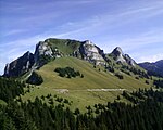
Mont Bichet, also known as Les Trables and, formerly, La Crêche, is a mostly wooded mountain in eastern France belonging to the Chablais Alps. Mont Bichet is the Haute-Savoie department and is surrounded by the three communes of the Brevon valley, Bellevaux, Lullin and Vailly. Its elevation is 1,360 m. Its slopes include many former Alpine pastures, now in ruins, covered by woodland and heavily populated with game animals.
Excerpt from the Wikipedia article Les Trables (License: CC BY-SA 3.0, Authors).Les Trables
Chemin rural de la Grosse Voie, Thonon-les-Bains
Geographical coordinates (GPS) Address Nearby Places Show on map
Geographical coordinates (GPS)
| Latitude | Longitude |
|---|---|
| N 46.278055555556 ° | E 6.5372222222222 ° |
Address
Chemin rural de la Grosse Voie
Chemin rural de la Grosse Voie
74470 Thonon-les-Bains
Auvergne-Rhône-Alpes, France
Open on Google Maps


