place

Buckland, Gloucestershire

Borough of TewkesburyCivil parishes in GloucestershireUse British English from March 2015Villages in Gloucestershire
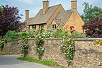
North wing of Buckland Manor geograph.org.uk 1549448

Buckland is a village and civil parish in the borough of Tewkesbury, Gloucestershire, England. The parish, which also includes the village of Laverton, had a population of 225 in 2010. The village is close to the Worcestershire border and 1.2 miles (2 km) south of Broadway. East of the village is the Burhill Iron Age hillfort. To the south, and within Buckland Parish, is the hamlet of Laverton. Within the village itself is the medieval Church of St Michael, a seventeenth-century manor house, and what claims to be the oldest Rectory in England.

Excerpt from the Wikipedia article Buckland, Gloucestershire (License: CC BY-SA 3.0, Authors, Images).

Buckland, Gloucestershire
The Lane,

Geographical coordinates (GPS) Address Nearby Places
placeShow on map

Wikipedia: Buckland, GloucestershireContinue reading on Wikipedia

Geographical coordinates (GPS)

Latitude Longitude
N 52.0232 ° E -1.8834 °
placeShow on map

Address

The Lane
WR12 7LY , Buckland
England, United Kingdom
mapOpen on Google Maps

North wing of Buckland Manor geograph.org.uk 1549448
Share experience

Nearby Places

Stanton, Gloucestershire

Stanton is a village and civil parish in Tewkesbury Borough, Gloucestershire, England. The village is a spring line settlement at the foot of the Cotswold escarpment, about 2+1⁄2 miles (4 km) southwest of Broadway in neighbouring Worcestershire. Broadway is Stanton's postal town. The 2011 Census recorded the parish's population as 198.The parish is about 3 miles (5 km) long on a northwest – southeast axis, embracing both low-lying land northwest of the village and high Cotswold land to the southeast. On the opposite northeast – southwest axis the parish is about 1+1⁄2 miles (2.4 km) across at its widest point. Its highest point is Shenberrow Hill on the escarpment in the southeast of the parish, 994 feet (303 m) above sea level. The low-lying northwestern part of the parish is bounded mostly by two streams, which converge and then join the River Isbourne about 1⁄2 mile (800 m) outside the parish. A report in 1712 indicated that the village consisted of 60 houses and 300 inhabitants, including 29 freeholders.Much of the area of the village was owned by the Stott family from 1906 to 1949. In addition to restoring the properties, these owners built a reservoir in 1907, added lighting to the main street, improved the church, extended the school, built a swimming pool and cricket field. Today, the village has no school, post office or shops.The village is built almost completely of Cotswold stone, a honey-coloured Jurassic limestone. Several cottages have thatched roofs. It has a high street, with a pub, The Mount, at the end. David Verey calls it "architecturally, the most distinguished of the smaller villages in the North Cotswolds". The Daily Telegraph described Stanton in 2017 as "arguably the most beautiful Cotswold village of them all" while the Huffington Post said that it's "one of the prettiest and idyllic unspoilt villages of the Cotswolds".The Cotswold Way long-distance footpath passes through the village.