place

Vilm

Bay of GreifswaldBiosphere reserves of GermanyGerman islands in the BalticIslands of Mecklenburg-Western PomeraniaPutbus
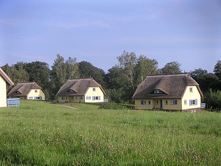
Gaestehaeuser auf Vilm

The Baltic Sea island of Vilm lies in the bay south of the much larger island of Rügen, and is one of Germany's most remote and tranquil spots. Covering less than 1 square kilometre (0.39 sq mi), Vilm is the remnant of a moraine left as the glaciers retreated about 6000 years ago. Since its formation the shape of the island has gradually changed, with sandbars and beaches forming and eroding continuously. Today the island is shaped like a 2.5-kilometre-long (1.6 mi) tadpole, consisting of two distinct parts. Great Vilm, the "head" to the north-east, rises to almost 40 metres (130 ft). The low-lying isthmus of Middle Vilm forms a long "tail" to the south-west, which culminates in Little Vilm, a rocky mound about 20 metres (66 ft) above sea level. The chalky cliffs to the southern side of Great Vilm are rapidly eroding, while sandbanks are building to add a snail-like curl to the tail.

Excerpt from the Wikipedia article Vilm (License: CC BY-SA 3.0, Authors, Images).

Geographical coordinates (GPS)

Latitude Longitude
N 54.316666666667 ° E 13.533333333333 °
placeShow on map

Address

Insel Vilm

Rundwanderweg
18581
Mecklenburg-Vorpommern, Germany
mapOpen on Google Maps

Gaestehaeuser auf Vilm
Share experience

Nearby Places

Goor-Muglitz Nature Reserve

The Goor-Muglitz Nature Reserve (German: Naturschutzgebiet Goor-Muglitz) is a nature reserve, covering an area of 157 hectares, in the German state of Mecklenburg-Vorpommern. It lies on the island of Rügen on the northern coastline of the Bay of Greifswald. It was granted protected status on 12 September 1990 as part of the creation of the Southeast Rügen Biosphere Reserve. The conservation aim of the two-part nature reserve is, on the one hand, the preservation and development of a deciduous forest of old trees in the Goor forest and the preservation of Freetz Lowland (Freetzer Niederung) and, on the other hand, the protection of a steep wooded slope near Muglitz, which is interspersed with wild fruit trees. The areas are in conservation zone 2 (buffer zone) of the biosphere reserve. The rocky shallow areas of the bay are also a protected area. The neighbouring villages are Lauterbach to the west and Freetz to the north. The status of the area is classified as "good" as the areas are able to develop largely undisturbed. However, interventions are being carried out to mitigate the effects of the past; such effects as the planting of conifers in some areas and the drainage of Freetz Lowland. Parts of the areas are owned by the Mecklenburg-Western Pomerania Foundation for the Environment and Conservation as well as the Michael Succow Foundation. Under EU law, the nature reserve is part of the SAC known as Southeast Rügen Coastal Landscape (Küstenlandschaft Südostrügen). Access to the nature reserve is possible using several public footpaths. The Succow Foundation has set up a nature trail.

Battle of Stresow
Battle of Stresow

The successful Landing on Groß Stresow by Prussian, Danish and Saxon troops took place on 15 November 1715 on the island of Rügen, Germany during the Great Northern War. The landing was followed with cavalry assaults from the Swedish defences on the island, commanded by Charles XII king of Sweden who despite the huge numerical disadvantage of - one up against five - chose to attack the fortified camp. The Swedes managed to get past the "Cheval de frise" and break through, but were then rapidly repulsed and routed after taking heavy casualties.The battle had lasted for almost an hour and Charles, who got his horse shot dead under him during the fight, later said: "Is there no god beside me?". The attack was supposed to work like a needle-manoeuvre "concentrate the full attack at one point, break through and then destroy the defences from the inside" used by the Swedes fifteen years earlier in the battle of Narva, where they were greatly successful and victorious.About five hundred Swedes were either dead or wounded along with all their artillery captured. The allied casualties were: 43 dead and 121 wounded Danes 36 Saxons and 49 Prussians dead or wounded. This was, however, probably the first notable Swedish field-battle defeat led directly by Charles XII. With the landing secured the alliance continued fighting off the last remaining Swedes on the island of Rügen and later joined up with the troops laying siege to Stralsund.

Wreechener See Nature Reserve

The Wreechener See Nature Reserve (German: Naturschutzgebiet Wreechener See) is a nature reserve in the German state of Mecklenburg-Vorpommern. It lies 2 kilometres south of the town of Putbus and has an area of 72 hectares. It was placed under protection on 12 September 1990 as part of the creation of the Southeast Rügen Biosphere Reserve. The purpose of its designation as a nature reserve is to preserve a lagoon-like cove (or bodden) in the Bay of Greifswald as one of the last regional quiet areas for resting water birds. The Wreechener See also has areas undergoing natural silting up that support special communities and are breeding grounds for rare bird species. Adjacent wet meadows are extensively used. Nearby villages are Wreechen, immediately to the east, Krakvitz and Neukamp. The cove is linked to the Bay of Greifswald by a short narrow channel spanned by a wooden road bridge. The condition of the reserve is only classed as satisfactory, because the water condition is affected by discharges of agricultural fertiliser. In 1997, there was mass fish mortality due to the lack of oxygen in the water of this hypertrophic lake. The macrophyte flora almost entirely disappeared, but has recolonised the lake in several areas. Reed continues to be harvested for thatch within the reserve. In the north of the reserve there is a refuge hut with a good view of the lake and the Baltic Sea beyond. The road from Neukamp to Wreechen runs immediately along the eastern border of the reserve. According to EU law, the area is a Special Area of Conservation as well as a Special Protection Area for birds.