place

Mount Greylock

Civilian Conservation Corps in MassachusettsDefunct ski areas and resorts in MassachusettsHighest points of U.S. statesHistoric districts on the National Register of Historic Places in MassachusettsMountains of Berkshire County, Massachusetts
Mountains on the Appalachian TrailNRHP infobox with nocatNational Natural Landmarks in MassachusettsNational Register of Historic Places in Berkshire County, MassachusettsNorth Adams, MassachusettsNorth American 1000 m summitsTaconic MountainsUse mdy dates from August 2023
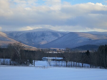
Greylock & Hopper
Greylock & Hopper

Mount Greylock in northwest Massachusetts is the highest point in the state at 3,489 feet (1,063 meters). The peak played a role in early American literature, and is part of the Taconic Mountains, which are geologically distinct from the nearby Berkshires and Green Mountains. Expansive views and a small area of sub-alpine forest characterize its upper reaches. A seasonal automobile road crosses the summit area near three structures from the 1930s which together constitute a small, "National Historic District." Various hiking paths including the Appalachian Trail traverse the area, which is part of the larger Mount Greylock State Reservation.

Excerpt from the Wikipedia article Mount Greylock (License: CC BY-SA 3.0, Authors, Images).

Mount Greylock
Appalachian Trail,

Geographical coordinates (GPS) Address Nearby Places
placeShow on map

Wikipedia: Mount GreylockContinue reading on Wikipedia

Geographical coordinates (GPS)

Latitude Longitude
N 42.63704 ° E -73.16593 °
placeShow on map

Address

Massachusetts Veterans War Memorial Tower

Appalachian Trail
01220
Massachusetts, United States
mapOpen on Google Maps

Greylock & Hopper
Greylock & Hopper
Share experience

Nearby Places

Mount Fitch (Massachusetts)

Mount Fitch is the third-highest peak in the Commonwealth of Massachusetts at 3,110 feet (950 m). It is located on the ridge between Mount Greylock at 3,491 feet (1,064 m) to its south and Mount Williams at 2,956 feet (901 m) to its north. The peak sits in the northwest corner of the Town of Adams (originally known as the Town of East Hoosac) in Berkshire County. The forested summit is approximately 123 yards (112 m) due west of a local high-point on the Appalachian Trail. Mount Fitch does not meet the Appalachian Mountain Club's prominence criterion of 200 vertical feet of separation from adjacent peaks as outlined in New England's Four-thousand footers list. Currently there is no side-spur trail or signage directing a hiker to the summit of Mt. Fitch from the Appalachian Trail; however, there is a wooden placard at the summit itself (pictured at right). The top is infrequently visited by hikers due to its anonymity, the bushwhack necessary to reach the top and the viewless summit. The peak is named for Ebenezer Fitch, who served as president of Williams College in nearby Williamstown, Massachusetts from 1793-1815. The name and geographic significance of the peak were disparaged by R.R.R. Brooks in his 1953 history of Williamstown, "[I]t is doubtful whether more than one resident in ten knows Mt. Williams from Mt. Fitch".In 1947, local residents Dr. Joseph Wilk and Bartlett Hendricks terminated clear cutting the summit of Mount Fitch, which remains overgrown to this date.

P. J. Barrett Block
P. J. Barrett Block

The P.J. Barrett Block is a historic block in Adams, Massachusetts. It is one of the four brick buildings on Park Street along with the Jones Block, Armory Block, and the Mausert Block, opposite the Town Hall. The block was built in roughly 1880, during a period of rapid industrial expansion in Adams. The original uses of the building were to provide retail shops on the ground floor and apartment-style housing above, a common feature of buildings of the period. It has a somewhat utilitarian appearance, which may be reflective of the relative haste in which it was designed and built. The building has a brick face, and the windows on the upper floors have curved pediments. The building was listed on the National Register of Historic Places in 1982.In 1984, after a period of abandonment, the building was rehabilitated by Dawson Associates into two commercial spaces and eight apartments of affordable housing. Financing was a blended form from an area bank, the (then) Massachusetts Government Land Bank under a pilot program to encourage changes in local tax abatement procedures to incentivize the redevelopment of abandoned properties, and the Town of Adams. Dawson Associates consisted of Mr. Donald Ruffer a prominent area Realtor, Mr. Richard Moscatelli, Executive Director of Housing Now, and Carter Terenzini, the City of Pittsfield's first Commissioner of Community and Economic Development and subsequently a Principal of RCT Associates. All were from Pittsfield, MA. In June 2016, a fire on a stove in a third floor apartment, displaced four families and resulted in damage to the upper floors and attic.