Bexton
Cheshire geography stubsCivil parishes in CheshireVillages in Cheshire

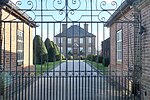
Bexton is a civil parish to the south west of Knutsford, in the unitary authority of Cheshire East, England. According to the 2001 census it had a population of 9. At the 2011 Census the population remained minimal, and details are included in the civil parish of Peover Inferior. Bexton Hall is designated by English Heritage as a Grade II* listed building, and is the only listed building in the parish.
Excerpt from the Wikipedia article Bexton (License: CC BY-SA 3.0, Authors, Images).Bexton
Blackhill Lane,
Geographical coordinates (GPS) Address Nearby Places Show on map
Geographical coordinates (GPS)
| Latitude | Longitude |
|---|---|
| N 53.288 ° | E -2.389 ° |
Address
Blackhill Lane
WA16 0EQ
England, United Kingdom
Open on Google Maps


