place

Île-aux-Ruaux

1630s in Canada1639 in New FranceCanada island stubsIslands of the Saint Lawrence RiverLandforms of Capitale-Nationale
Quebec geography stubsRiver islands of QuebecUse Canadian English from January 2023

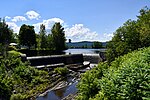
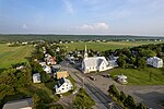
Île-aux-Ruaux (Ile aux Réaux, Ile des Ruaux, Île au Ruau, and others) is one of the oldest concessions in the history of New France. The whole island was granted to the Jesuits in 1638 by the Company of One Hundred Associates. The Jesuits took possession in 1639. Among these first arrivals was François Byssot de la Rivière. The island lies in the Saint Lawrence River and is within easy access of Quebec City and Île d'Orléans. It is approximately 3.5 miles by .75 miles in size and is part of the Archipelago of Isle-aux-Grues. It is also a part of the municipality of Saint-François-de-l'Île-d'Orléans, in L'Île-d'Orléans Regional County Municipality. Île Reaux is now a private hunting island, home to a half-century-old estate, “Le Club de Chasse aux Brigands”. In 1962 the island was purchased by William O’Brien, a Montreal businessman, who had different plans. Being an avid and experienced hunter, he was well aware of flight paths of game birds. Just north of the island on the shore of the St. Lawrence River, is Cap Tourmente, amongst the largest concentration of Snow Geese in the world. Many were confused why a Montreal Stock Broker would want a farm on the St. Laurence. William was not as puzzled. Thus began “Club de Chasse aux Brigands” It has hosted family, friends, Royalty, Heads of State, Fortune 500 executives and many more.

Excerpt from the Wikipedia article Île-aux-Ruaux (License: CC BY-SA 3.0, Authors).

Geographical coordinates (GPS)

Latitude Longitude
N 47.013055555556 ° E -70.736944444444 °
placeShow on map

Address

Saint-François-de-l'Île-d'Orléans


G0A 3S0
Quebec, Canada
mapOpen on Google Maps

Share experience

Nearby Places

Grosse Isle
Grosse Isle

Grosse Isle (French: Grosse Île, "big island") is an island located in the St. Lawrence River in Quebec, Canada. It is one of the islands of the 21-island Isle-aux-Grues archipelago. It is part of the municipality of Saint-Antoine-de-l'Isle-aux-Grues, located in the Chaudière-Appalaches region of the province. Also known as Grosse Isle(the famine) and the Irish Memorial National Historic Site, the island was the site of an immigration depot which housed predominantly Irish immigrants coming to Canada to escape the Great Famine of 1845–1849. In 1832, the Lower Canadian Government had previously set up this depot to contain an earlier cholera epidemic that was believed to be caused by the large influx of European immigrants, and the station was reopened in the mid-19th century to accommodate Irish immigrants who had contracted typhus during their voyages. Thousands of Irish were quarantined on Grosse Isle from 1832 to 1848. It is believed that over 3,000 Irish people died on the island and that over 5,000 are currently buried in the cemetery there; many died en route. Most who died on the island were infected with typhus, a result of poor sanitary conditions there in 1847. Grosse Isle is the largest burial ground for refugees of the Great Famine outside Ireland. After Canadian Confederation in 1867, the buildings and equipment were modernized to meet the standards of the new Canadian government's immigration policies. Grosse Isle is sometimes referred to as Canada's Ellis Island (1892–1954), an association it shares with the Pier 21 immigration facility in Halifax, Nova Scotia. It is estimated that in total, from its opening in 1832 to its closing in 1932, almost 500,000 Irish immigrants passed through Grosse Isle on their way to Canada.