place

Temescal Valley, California

Census-designated places in Riverside County, CaliforniaElsinore Trough
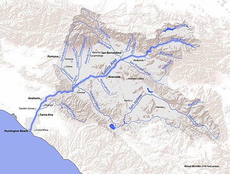
SAR Map
SAR Map

Temescal Valley (Temescal, Spanish for "sweat lodge") is a census-designated place in Riverside County, California. Temescal Valley sits at an elevation of 1,138 feet (347 m). The 2010 United States census reported Temescal Valley's population was 22,535.

Excerpt from the Wikipedia article Temescal Valley, California (License: CC BY-SA 3.0, Authors, Images).

Temescal Valley, California
Evergreen Loop,

Geographical coordinates (GPS) Address Nearby Places
placeShow on map

Wikipedia: Temescal Valley, CaliforniaContinue reading on Wikipedia

Geographical coordinates (GPS)

Latitude Longitude
N 33.757777777778 ° E -117.4675 °
placeShow on map

Address

Evergreen Loop 10966
92883 , Sycamore Creek
California, United States
mapOpen on Google Maps

SAR Map
SAR Map
Share experience

Nearby Places

Temescal Butterfield stage station

The Temescal Butterfield stage station is the site where the Butterfield Overland Mail stagecoach stopped to deliver mail and get fresh horses in what is now Riverside County, California. The Temescal Butterfield stage station was designated a California Historic Landmark (No.188) on June 20, 1935. The site of the Temescal Butterfield stage station is currently near the City of Corona along Temescal Canyon Road. The first stagecoach with mail and passengers departed Tipton, Missouri on September 15, 1858. The stagecoach stopped at the Temescal Butterfield stage station and arrived at the Butterfield Overland Mail Company Los Angeles Building on October 7, 1858. The Butterfield Overland Mail Company closed in 1861.The Temescal Butterfield stage station was built five miles (8 km) north of the Temescal Hot Springs, ten miles (16 km) north of Rancho La Laguna station and twenty miles (32 km) south of the Chino Rancho station. The Temescal Butterfield stage station was "at the foot of the Temescal hills, a splendid place to camp, wood and water plenty, and protected from the winds." Temescal had its own post office from February 12, 1861, to November 12, 1861. Around this location, the settlement of Temescal grew over the next few decades. By 1860, Greenwade's Place at Temescal, three miles (4.8 km) north of the stage station, was a polling place for southwestern San Bernardino County. Voting irregularities there that year resulted in a court case between the candidates for a California State Assembly seat. The trial was so contentious it included the shooting of Bethel Coopwood, one of the opposing lawyers by the other in court, before the results could be determined.
Rice Canyon Creek

Rice Canyon Creek is a tributary creek or arroyo of Temescal Creek in Riverside County, California. Rice Canyon Creek has its source at the head of Rice Canyon at an elevation of 3440 feet in the Santa Ana Mountains at 33°41′54″N 117°24′11″W east of the 4313 foot peak on the north south divide of the range. It is a wash that runs down from the canyon mouth 33°41′07″N 117°27′08″W at 1631 feet to its mouth at its confluence with Temescal Creek near Alberhill, California at an elevation of 1220 feet. Rice Canyon Creek has a tributary, Bishop Canyon Creek which enters the wash on the left a little below the mouth of Rice Canyon at 33°42′05″N 117°24′07″W.Rice Canyon Creek flows in the rainy season in its upper reach but is an ephemeral arroyo in its lower reach below the narrows 0.80 miles above the canyon mouth, and flows on the surface below the narrows only after more heavy rain events, and is dry the rest of the year. Rice Canyon's creek flows during the rainy season below its narrows to its mouth but its surface flow dries up below the narrows about 0.8 miles above its mouth in the canyon during the dry season, and above that in years with severe drought conditions. However some waterholes remain even in the dry years in the upper reach. Much of the wash in modern times has been interrupted by clay mining operations that stops the surface flows of water from Rice Canyon Creek from reaching Temescal Creek.