place

Bagendon

Cotswold DistrictGloucestershire geography stubsOpenDomesdayUse British English from February 2015Villages in Gloucestershire
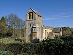
Bagendon Church geograph.org.uk 1551148

Bagendon is a village and civil parish in the Cotswold district of Gloucestershire, England, about four miles (6 km) north of Cirencester. According to the 2001 census it had a population of 265,decreasing to 239 at the 2011 census.

Excerpt from the Wikipedia article Bagendon (License: CC BY-SA 3.0, Authors, Images).

Bagendon
Welsh Way, Cotswold District Bagendon

Geographical coordinates (GPS) Address Nearby Places
placeShow on map

Wikipedia: BagendonContinue reading on Wikipedia

Geographical coordinates (GPS)

Latitude Longitude
N 51.75 ° E -1.98 °
placeShow on map

Address

Welsh Way

Welsh Way
GL7 7BP Cotswold District, Bagendon
England, United Kingdom
mapOpen on Google Maps

Bagendon Church geograph.org.uk 1551148
Share experience

Nearby Places

Baunton
Baunton

Baunton is a village and civil parish in the Cotswold district of Gloucestershire, England, located about two miles north of Cirencester on the River Churn. There is archaeological evidence of human habitation around the village in Prehistoric and Roman times. The village is recorded in Domesday Book in 1086 under the name of Baudintone which means an estate associated with a man called Balda.The Norman church of St Mary Magdalene was built by the Augustinian monks of Cirencester Abbey as a Chapel of Ease in about 1150. Inside there is large wall painting, probably dating from the 14th century, which depicts St Christopher carrying the Christ Child across a stream. It became the parish church in 1551. The village contains a number of Grade II listed buildings including the 16th century Manor House, and Baunton Mill. The village is in an Area of Outstanding Natural Beauty and much of it is classified a Conservation Area. The Manor of Baunton belonged to a succession of families including the George and Chester Master families. John George of Baunton was MP for Cirencester at the time of the Civil War. He was initially a Parliamentarian, but when his life was spared by the Royalists who had captured him, he converted to the King's side.According to the 2001 census it had a population of 290, increasing to 299 at the 2011 census.The village is at the southern edge of the Churn Valley electoral ward, which stretches up the valley to Coberley. The total ward population taken at the 2011 census was 1,970.

Cotswold District
Cotswold District

Cotswold is a local government district in Gloucestershire, England. It is named after the wider Cotswolds region and range of hills. The council is based in the district's largest town of Cirencester. The district also includes the towns of Chipping Campden, Fairford, Lechlade, Moreton-in-Marsh, Northleach, Stow-on-the-Wold and Tetbury, along with numerous villages and surrounding rural areas. The district covers nearly 450 square miles (1,200 km2), with some 80% of the land located within the Cotswolds Area of Outstanding Natural Beauty. The much larger area referred to as the Cotswolds encompasses nearly 800 square miles, spanning five counties: Gloucestershire, Oxfordshire, Warwickshire, Wiltshire, and Worcestershire. This large Area of Outstanding Natural Beauty had a population of 139,000 in 2016.Eighty per cent of the district lies within the River Thames catchment area, with the Thames itself and several tributaries including the River Windrush and River Leach running through the district. Lechlade is an important point on the river as the upstream limit of navigation. In the 2007 floods in the UK, rivers were the source of flooding of 53 per cent of the locations affected and the Thames at Lechlade reached record levels with over 100 reports of flooding.The neighbouring districts are South Gloucestershire, Stroud, Tewkesbury, Cheltenham, Wychavon, Stratford-on-Avon, West Oxfordshire, Vale of White Horse, Swindon and Wiltshire.