Roanhead
Beaches of CumbriaDefunct mining companies of the United KingdomHeadlands of EnglandLandforms of CumbriaTourist attractions in Barrow-in-Furness

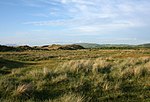
Roanhead (sometimes spelled Ronhead) refers to the limestone outcrop of Roanhead Crag in Cumbria and the farmland behind it, but in recent years the term has been taken to mean the sandy beaches adjoining Sandscale Haws extending to Snab Point. The Irish Sea lies to the west of Roanhead, whilst the Duddon Estuary and Walney Channel are due north and south respectively. The beach is noted for its abundance of sand dunes and strong, often dangerous coastal currents. Today the beach is a National Trust conservation area, and a two-mile stretch of the Cumbria Coastal Way runs through it.
Excerpt from the Wikipedia article Roanhead (License: CC BY-SA 3.0, Authors, Images).Roanhead
Hawthwaite Lane,
Geographical coordinates (GPS) Address Website Nearby Places Show on map
Geographical coordinates (GPS)
| Latitude | Longitude |
|---|---|
| N 54.1648 ° | E -3.2415 ° |
Address
Sandscale Haws Nature Reserve
Hawthwaite Lane
LA14 4QJ , Askam and Ireleth
England, United Kingdom
Open on Google Maps


