place

Reintalanger Hut

1912 establishments in GermanyBuildings and structures completed in 1912Buildings and structures in Garmisch-Partenkirchen (district)Mountain huts in GermanyWetterstein
Reintalangerhuette HQ

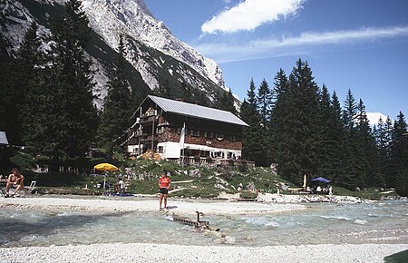
The Reintalanger Hut (1,366 m) is an Alpine Club hut in the Wetterstein Mountains at the head of the Reintal valley. The River Partnach has its source in the vicinity. West of the hut the valley floor climbs steeply up to the plateau of the Zugspitzplatt below Germany's highest mountain. The hut belongs to the Munich section of the German Alpine Club and the administrative district of Garmisch-Partenkirchen. It was built in 1912 and is a Category 1 hut. The house has 132 bedspaces and is managed from the end of May to mid-October.

Excerpt from the Wikipedia article Reintalanger Hut (License: CC BY-SA 3.0, Authors, Images).

Reintalanger Hut
Schützensteig,

Geographical coordinates (GPS) Address External links Nearby Places
placeShow on map

Wikipedia: Reintalanger HutContinue reading on Wikipedia

Geographical coordinates (GPS)

Latitude Longitude
N 47.40528 ° E 11.03556 °
placeShow on map

Address

Reintalangerhütte

Schützensteig 1
82467
Bavaria, Germany
mapOpen on Google Maps

linkWikiData (Q917130)
linkOpenStreetMap (173682244)

Reintalangerhuette HQ
Share experience

Nearby Places

Hochwanner
Hochwanner

At 2,744 metres (9,003 ft), the Hochwanner (formerly: Kothbachspitze) is the second highest mountain in Germany after the Zugspitze (if the somewhat higher Schneefernerkopf is only considered as a sub-peak of the Zugspitze). In addition the Hochwanner is the highest peak on the main ridge of the Wetterstein (Wettersteinhauptkamm) running from Gatterl to the Upper Wettersteinspitze (Oberen Wettersteinspitze) above Mittenwald in an east–west direction. From the Hochwanner massif there is an all-round view of the Rein valley (Reintal), the Leutasch valley in Austria, the Gais valley, the Zugspitze, the Mieming Chain, the Jubiläumsgrat, the Karwendel mountains and far into the central Alps.Despite being the second highest peak in Germany and having a north face which drops about 1500 m (one of the highest rock faces in the whole of the Northern Limestone Alps) the Hochwanner has remained a relatively unknown mountain. This is due to its relatively inaccessible location, behind the Alpspitze and hidden by the Höllentalspitze. The more widely known, but lower Watzmann is often wrongly cited as the second highest mountain in Germany. The easiest route to the summit is from the south from the Rotmoosalm (3 hours) or from Gatterl. Pathless in places or only recognisable by a faint trail it initially runs up steep grass meadows, later over a short rock climb (grade I on the UIAA scale) and then mainly over steep, laborious scree slopes to the summit. The route is sparingly marked with cairns. The north face is a very long climb. Hochwanner was first climbed by Hermann von Barth in 1870.