place

Hinterreintalschrofen

Mountains of BavariaMountains of Tyrol (state)Mountains of the AlpsTwo-thousanders of AustriaTwo-thousanders of Germany
Hinterreintalschrofen Hohe Munde 20170722

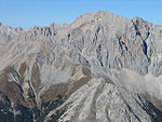
The Hinterreintalschrofen is a 2,669 m high peak on the main, east-west oriented crest (the Teufelsgrat or "Devil's Ridge") of the Wetterstein Mountains in the Eastern Alps. It is a massive and dominant mountain with a high rock face that plunges into the Reintal valley to the north and stamps the appearance of the Wetterstein when seen from the north. In spite of that, the mountain is rarely climbed. Its neighbouring peaks are the Hochwanner (2,746 m) to the west and the Hundstallköpfe (2,533 m) to the east. The Teufelsgrat runs along the national border between the Austrian state of Tyrol, (Gaistal) in the south and the German state of Bavaria, (Reintal) in the north.

Excerpt from the Wikipedia article Hinterreintalschrofen (License: CC BY-SA 3.0, Authors, Images).

Hinterreintalschrofen
Südwandsteig,

Geographical coordinates (GPS) Address Nearby Places
placeShow on map

Wikipedia: HinterreintalschrofenContinue reading on Wikipedia

Geographical coordinates (GPS)

Latitude Longitude
N 47.39611 ° E 11.07583 °
placeShow on map

Address

Südwandsteig

Südwandsteig
6105
Tyrol, Austria
mapOpen on Google Maps

Hinterreintalschrofen Hohe Munde 20170722
Share experience

Nearby Places

Hochwanner
Hochwanner

At 2,744 metres (9,003 ft), the Hochwanner (formerly: Kothbachspitze) is the second highest mountain in Germany after the Zugspitze (if the somewhat higher Schneefernerkopf is only considered as a sub-peak of the Zugspitze). In addition the Hochwanner is the highest peak on the main ridge of the Wetterstein (Wettersteinhauptkamm) running from Gatterl to the Upper Wettersteinspitze (Oberen Wettersteinspitze) above Mittenwald in an east–west direction. From the Hochwanner massif there is an all-round view of the Rein valley (Reintal), the Leutasch valley in Austria, the Gais valley, the Zugspitze, the Mieming Chain, the Jubiläumsgrat, the Karwendel mountains and far into the central Alps.Despite being the second highest peak in Germany and having a north face which drops about 1500 m (one of the highest rock faces in the whole of the Northern Limestone Alps) the Hochwanner has remained a relatively unknown mountain. This is due to its relatively inaccessible location, behind the Alpspitze and hidden by the Höllentalspitze. The more widely known, but lower Watzmann is often wrongly cited as the second highest mountain in Germany. The easiest route to the summit is from the south from the Rotmoosalm (3 hours) or from Gatterl. Pathless in places or only recognisable by a faint trail it initially runs up steep grass meadows, later over a short rock climb (grade I on the UIAA scale) and then mainly over steep, laborious scree slopes to the summit. The route is sparingly marked with cairns. The north face is a very long climb. Hochwanner was first climbed by Hermann von Barth in 1870.

Dreitorspitze
Dreitorspitze

The Dreitorspitze is a large and very prominent, multi-peak mountain massif in the eastern part of the Wetterstein Mountains in southern Germany. It is divided into Partenkirchen Dreitorspitze (German: Partenkirchener Dreitorspitze) at 2,633 metres (8,638 ft) and Leutasch Dreitorspitze (German:Leutascher Dreitorspitze) at 2,682 metres (8,799 ft); each of which has several peaks. The main peak of the fourth highest mountain massif in Germany is the Leutasch Dreitorspitze, which is also known as the Karlspitze. The Dreitorspitze marks the spot where the main chain of the Wetterstein mountains changes direction from its primary east–west orientation to run northwards for a short distance, before turning back again onto its main axis. East of the Dreitorspitze lies the karst plateau of the Leutasch Platt, comparable to the Zugspitzplatt at the foot of the Zugspitze. The easiest route to the main peaks may be climbed at grades 1 and 2. An easy Klettersteig runs up to the western summit of the Partenkirchen Dreitorspitze, secured with cables, which is named after the famous explorer of the Northern Limestone Alps, Hermann von Barth. All the other peaks are reserved for climbers. Climbing the peaks is usually part of a two-day tour with an overnight stop at the Meilerhütte hut. A one-day tour requires climbers to be in very good condition. Valley settlements: Partenkirchen (Germany), Leutasch (Austria), Mittenwald (Germany) Bases: Meilerhütte (Garmisch-Partenkirchen Section of the German Alpine Club)