place

Conejo Grade

Camarillo, CaliforniaConejo ValleyGeography of Thousand Oaks, CaliforniaGeography of Ventura County, CaliforniaHistoric trails and roads in California
History of Ventura County, CaliforniaRoads in Ventura County, CaliforniaSanta Monica MountainsU.S. Route 101Use mdy dates from February 2022
Conejo grade
Conejo grade

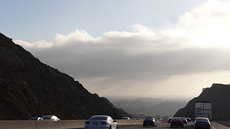
The Conejo Grade is a 7% grade incline on a section of US 101 (the Ventura Freeway). Also known as the Camarillo Grade, it links Thousand Oaks and cities of the Conejo Valley, with Camarillo and the cities on the Oxnard Plain. With a summit elevation of 841.1 feet (256.4 m), California Highway Patrol inspection stations for trucks are situated on both sides of the highway at the upper terminus of the grade.The Conejo Mountain has functioned as a barrier by separating Ventura County into East County and West County. Historically, the mountain was known for its many jackrabbits and prickly pear cacti. The surrounding area was formed by volcanic eruptions millions of years ago, a rare geological formation in Southern California. Within the traditional lands of the Chumash people, they had a trading trail through the pass, and it later served as a trading route for farmers and their wagons down the Conejo Grade to the Hueneme wharf. The grade experienced improvements by the newly established State Highway Department in 1912, when the road measured six miles (9.7 km) long and had 49 curves. Traffic kept increasing and the road was straightened and relocated in 1935. The new road was a mile shorter and only had twelve curves.

Excerpt from the Wikipedia article Conejo Grade (License: CC BY-SA 3.0, Authors, Images).

Conejo Grade
Ventura Freeway,

Geographical coordinates (GPS) Address Nearby Places
placeShow on map

Wikipedia: Conejo GradeContinue reading on Wikipedia

Geographical coordinates (GPS)

Latitude Longitude
N 34.200277777778 ° E -118.95944444444 °
placeShow on map

Address

Ventura Freeway (El Camino Real)

Ventura Freeway
91320
California, United States
mapOpen on Google Maps

Conejo grade
Conejo grade
Share experience

Nearby Places

Pepper Tree Playfield

Pepper Tree Playfield is a 21.7-acre community park located in western Newbury Park, California. It is located at the corner of Reino and Old Conejo Roads, and was acquired by the Conejo Recreation & Park District (CRPD) in 1977, but not developed nor opened until 1983. It contains a 0.83-mile fitness trail loop, and is nearby numerous trailheads. The park is within walking distance from the Conejo Vista Trailhead in Old Conejo Open Space, located immediately north of Pepper Tree Playfield, and the park is directly across the street from the Knoll Trailhead (Pepper Tree Vista Trail) in Knoll Open Space, which is to the park’s immediate east, crossing North Reino Road. It is also an access point for trails leading to the Conejo Mountain. Pepper Tree Playfield is named for its many pepper trees, which surrounds the park area. The park is managed by the Conejo Recreation & Park District (CRPD), It contains three parking stalls, bleacher seating for 120, picnic tables and structures, a playground, four soccer fields, and two softball fields. The park is used for a variety of recreational activities, including but not limited to hiking, football, softball, cross country running, soccer, camping, running, and bird observation.Pepper Tree Playfield, along with Dos Vientos Community Park, is home to American Youth Soccer Organization (AYSO) Region 42 (Newbury Park) and draws hundreds of players and spectators during the AYSO season, with fields here utilized for games on weekends during half of the year beginning in September.To get here from the Ventura Freeway in Newbury Park, CA, take the Exit for Wendy Drive. If coming from Los Angeles, turn left from the off-ramp onto Wendy Dr. then turn right immediately over the bridge on Old Conejo Road at the Mobil Station. If coming from Ventura/Santa Barbara, proceed straight from the off-ramp; this will place you on Old Conejo Road. After one mile, park at Pepper Tree Playfield. It is situated at 3720 Old Conejo Road.

Casa Conejo, California

Casa Conejo ( ; Spanish for "Rabbit House") is an unincorporated county island in Newbury Park, Ventura County, California, United States. It was the first planned community in Newbury Park and began building in 1960. When the city of Thousand Oaks incorporated 4 years later, the new developments in Newbury Park were incorporated into the city boundaries before being subdivided. The community is bordered by Old Conejo Road and US 101 to the north, Borchard Road to the south, Jenny Drive to the west, and Sequoia Middle School to the east. For statistical purposes, the United States Census Bureau has defined Casa Conejo as a census-designated place (CDP). The census definition of the area may not precisely correspond to local understanding of the area with the same name. The population was 3,249 at the 2010 census, up from 3,180 at the 2000 census. Casa Conejo is located in a roughly rectangle-shaped unincorporated area surrounded by the city of Thousand Oaks. The Casa Conejo Municipal Advisory Council (MAC) serves Casa Conejo residents, and makes recommendations to the Board of Supervisors. Its purpose is to provide a forum for Casa Conejo residents to discuss issues and come with ideas to the Board of Supervisors. While numerous other unincorporated islands were ultimately annexed by the City of Thousand Oaks during the 1980s, Casa Conejo voters rejected such efforts and remains an unincorporated pocket surrounded by Newbury Park. While Newbury Park is in Thousand Oaks, Casa Conejo is in Newbury Park but not in Thousand Oaks.