South Fork Coos River
Rivers of Coos County, OregonRivers of Oregon
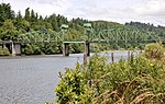
The South Fork Coos River is a tributary, about 32 miles (51 km) long, of the Coos River in the U.S. state of Oregon. Formed by the confluence of the Williams River and Tioga Creek, it begins in eastern Coos County near the Douglas County line and flows generally northwest through the Southern Oregon Coast Range. East of the city of Coos Bay, it joins the Millicoma River to form the Coos River. This larger river, only about 5 miles (8 km) long, empties into the eastern end of Coos Bay, which connects to the Pacific Ocean.
Excerpt from the Wikipedia article South Fork Coos River (License: CC BY-SA 3.0, Authors).South Fork Coos River
South Coos River Lane,
Geographical coordinates (GPS) Address Nearby Places Show on map
 Continue reading on Wikipedia
 Geographical coordinates (GPS)
| Latitude | Longitude |
|---|---|
| N 43.3775 ° | E -124.09916666667 ° |
Address
South Coos River Lane 96662
97420
Oregon, United States
Open on Google Maps