place

Millicoma River

Oregon placenames of Native American originRivers of Coos County, OregonRivers of Oregon
Millicoma river
Millicoma river

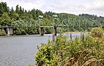
The Millicoma River is a coast stream, about 8.5 miles (13.7 km) long, east of Coos Bay in the U.S. state of Oregon. Formed by the confluence of the East Fork Millicoma River and the West Fork Millicoma River at Allegany, it meanders across relatively flat land to meet the South Fork Coos River, with which it forms the Coos River.Oregon Route 241 (Coos River Highway) runs along the right bank of the river from Allegany to the mouth. The Millicoma meanders generally southwest, receiving Woodruff Creek from the left slightly downstream from Allegany. Deton Creek enters from the right at Rooke Higgins County Park near river mile (RM) 3.5 or river kilometer (RK) 5.6. About a half-mile later, Hendrickson Creek enters from the left. The Millicoma receives Matt Davis Creek from the right just before meeting the South Fork Coos River to form the Coos River about 5 miles (8 km) from the larger stream's mouth on Coos Bay.The Millicoma supports a large run of shad as well as runs of Chinook salmon and steelhead, all of which may be fished for. It also supports runs of Coho salmon, but fishing for them in the Millicoma is not allowed. Rooke Higgins County Park has a boat launch as does Doras Ramp, near the mouth.

Excerpt from the Wikipedia article Millicoma River (License: CC BY-SA 3.0, Authors, Images).

Millicoma River
Sand D Road,

Geographical coordinates (GPS) Address Nearby Places
placeShow on map

Wikipedia: Millicoma RiverContinue reading on Wikipedia

Geographical coordinates (GPS)

Latitude Longitude
N 43.38 ° E -124.09805555556 °
placeShow on map

Address

Sand D Road

Sand D Road

Oregon, United States
mapOpen on Google Maps

Millicoma river
Millicoma river
Share experience

Nearby Places

East Fork Millicoma River

The East Fork Millicoma River is a tributary, about 24 miles (39 km) long, of the Millicoma River in the U.S. state of Oregon. Rising in eastern Coos County, it flows generally west to the community of Allegany, where it joins the West Fork Millicoma River to form the Millicoma. In turn, the Millicoma, which is only about 9 miles (14 km) long, joins the South Fork Coos River to form the Coos River. The Coos River, itself only about 5 miles (8 km) long, empties into the eastern end of Coos Bay, which connects to the Pacific Ocean.Forming north of Coos Ridge in the Southern Oregon Coast Range near Ivers Peak, the river flows west, receiving Beulah Creek from the right about 18 miles (29 km) from the mouth. About 6 miles (9.7 km) further downstream, Little Matson Creek enters from the right, and a mile or so later Fox Creek enters from the left. The river receives Glenn Creek from the right about 7 miles (11 km) from the mouth. Glenn Creek and one of its tributaries, Silver Creek, cascade over Golden and Silver falls in the Golden and Silver Falls State Natural Area. The East Fork Millicoma River then passes a stream gauge managed by the Coos Watershed Association.Rodine Creek enters from the left about 2 miles (3 km) later. Just below the confluence with Rodine Creek, Nesika County Park is on the left, and Hodges Creek enters from the left. Less than a mile from Allegany, Marlow Creek enters from the right and then Nowlit Creek, also from the right, before the East Fork meets the West Fork to form the Millicoma. East Fork Millicoma Road runs parallel to the river for much of its course.The river supports coastal cutthroat trout and a run of winter steelhead. Nesika County Park, about 2.5 miles (4.0 km) east of Allegany on East Fork Millicoma Road, offers bank access for steelhead fishing.