Îles Laval
Former municipalities in QuebecHochelaga ArchipelagoLandforms of Laval, QuebecNeighbourhoods in Laval, QuebecPopulated places disestablished in 1965 ... and 3 more
Quebec geography stubsRivière des PrairiesUse Canadian English from January 2023

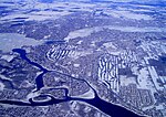
The Îles Laval are an island grouping in the Rivière des Prairies in southwestern Quebec, part of the Hochelaga Archipelago. Formerly an independent municipality (Les Îles-Laval), they became part of the city of Laval on August 6, 1965.
Excerpt from the Wikipedia article Îles Laval (License: CC BY-SA 3.0, Authors, Images).Îles Laval
Chemin du Tour, Laval (administrative region) Îles-Laval
Geographical coordinates (GPS) Address Nearby Places Show on map
Geographical coordinates (GPS)
| Latitude | Longitude |
|---|---|
| N 45.52 ° | E -73.853055555556 ° |
Address
REM
Chemin du Tour
H1Y 1Z0 Laval (administrative region), Îles-Laval
Quebec, Canada
Open on Google Maps


