place

Lugwardine

Civil parishes in HerefordshireHerefordshire geography stubsVillages in Herefordshire
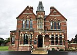
Lugwardine Church geograph.org.uk 1596726

Lugwardine is a village and civil parish in Herefordshire, England, to the east of Hereford. It lies on the north-east bank of the River Lugg, which gives the village its name. The population of the civil parish taken at the 2011 Census was 1,721.The place-name 'Lugwardine' is first attested in the Domesday Book of 1086, where it appears as Lucvordine. It appears as Lugwurthin in the Pipe Rolls of 1168. The name means 'enclosure or homestead on the (river) Lugg'.The village lies on the A438 road; Lugwardine Bridge takes this road across the Lugg. There is a public house in the village called The Crown and Anchor.St Mary's Roman Catholic High School is in the village. There is also a primary school, shared with neighbouring Bartestree.

Excerpt from the Wikipedia article Lugwardine (License: CC BY-SA 3.0, Authors, Images).

Lugwardine
Hereford Road,

Geographical coordinates (GPS) Address Nearby Places
placeShow on map

Wikipedia: LugwardineContinue reading on Wikipedia

Geographical coordinates (GPS)

Latitude Longitude
N 52.066 ° E -2.66 °
placeShow on map

Address

Hereford Road

Hereford Road
HR1 4RY , Bartestree
England, United Kingdom
mapOpen on Google Maps

Lugwardine Church geograph.org.uk 1596726
Share experience

Nearby Places

St Mary's Roman Catholic High School, Lugwardine

St. Mary's Roman Catholic School is a coeducational secondary school in the village of Lugwardine in Herefordshire, England which takes children of ages 11 to 16, ranked by Ofsted as Herefordshire's best state school based on GCSE results from the last 10 years. It is also a centre of excellence for English and the arts, having won the national student debating championship many times in recent years. The current headteacher is Mr. Wetson. In 2011 the school celebrated its 150th anniversary. Celebrations started on the week commencing 27 June, culminating in a major outdoor Mass attended by its three Roman Catholic feeder schools in Herefordshire (St Joseph's RC Primary School in Ross-on-Wye, Our Lady's Catholic Primary School and St Francis Xavier's RC Primary School in Hereford) on 2 July with additional public events. In 2021 the school was at the centre of controversy surrounding the teaching of sex and relationship education.On 20 April 2021, the school was inspected by Ofsted because Her Majesty's Chief Inspector "was concerned about pupils’ personal development, and the effectiveness of leadership and management (including governance) at the school". The inspection was conducted due to "concerns that the school’s current RSE programme encourages misogynistic and discriminatory attitudes". The formal inspection report letter of 14 May 2021 highlighted further priorities for improvement.

River Frome, Herefordshire

The River Frome is a river in Herefordshire, England. It flows through Bromyard, and Bishops Frome. Immediately below the depopulated village of Stretton Grandison its tributary, the river or brook named the Lodon, joins it. It then flows west, past Yarkhill and the farmstead or locality of Prior's Frome before its confluence with the Lugg (which skirts the north side of Hereford here) at Hampton Bishop about 2 miles (3.2 km) before the latter joins the Wye. The valley lies in the Old Red Sandstone formations of this part of Herefordshire, revealing much evidence of the region's geological past. It has left many exposures of Devonian and late Silurian sandstones and mudstones, and has created a landscape that demonstrates the effects of successive phases of glaciofluvial erosion. The river source is on the Bromyard plateau where it cuts through rocks of the St. Maughan's Formation. At the village of Bishop's Frome, the Bishop's Frome Limestone marks the transition to the older, Silurian Raglan Mudstone Formation and enters a broad, low-lying area, where the effects of both the Anglian and Devensian glacial stages can be seen in the rocks and landscape.The river gives its name to hamlets on the high ground to the east: Halmond's Frome, Fromes Hill and Castle Frome. In 2007, like many other rivers in England, the Frome burst its banks. This occurred at places including lower parts of Bromyard, causing homes to be evacuated. A smaller scale recurrence occurred in April and July 2012.