Shropshire Hills
Hills of ShropshireNatural regions of England

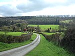
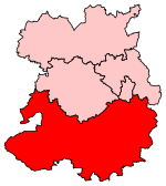
The Shropshire Hills are a dissected upland area and one of the natural regions of England. They lie wholly within the county of Shropshire and encompass several distinctive and well-known landmarks, such as the Long Mynd, Wenlock Edge, The Wrekin and the Clees. The Shropshire Hills lie south of the county town of Shrewsbury between the Welsh border and Much Wenlock, extending as far south as Ludlow. To the north they are bounded by the Shropshire, Cheshire and Staffordshire Plain, to the east by the Severn Valley and Mid Severn Sandstone Plateau, to the southeast by Knighton and the Teme Valley and to the southwest by the Clun and North West Herefordshire Hills.
Excerpt from the Wikipedia article Shropshire Hills (License: CC BY-SA 3.0, Authors, Images).Shropshire Hills
Rushbury Road,
Geographical coordinates (GPS) Address Nearby Places Show on map
Geographical coordinates (GPS)
| Latitude | Longitude |
|---|---|
| N 52.522 ° | E -2.719 ° |
Address
Rushbury Road
SY6 7DY
England, United Kingdom
Open on Google Maps


