place

St Caian's Church, Tregaian
14th-century church buildings in WalesChurch in Wales church buildingsGrade II* listed churches in AngleseyLlanddyfnan
St Caian's Church, Tregaian

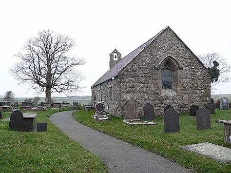
St Caian's Church, Tregaian, also known as St Caean's Church, Tregaean, is a small medieval church dating from the 14th century in Anglesey, north Wales. It is dedicated to St Caian, a Christian from the 5th or 6th century about whom little is known. The building contains a late 14th-century east window and a late 15th-century doorway. The churchyard contains the grave of William ap Howel, who died in 1581 at the age of 105, leaving over forty children between the ages of 8 and 89 and over three hundred living descendants. The church is still used for worship by the Church in Wales, and is one of three churches in a combined parish. It is a Grade II* listed building, a national designation given to "particularly important buildings of more than special interest", in particular because it is regarded as "an excellent late Medieval rural church".

Excerpt from the Wikipedia article St Caian's Church, Tregaian (License: CC BY-SA 3.0, Authors, Images).

St Caian's Church, Tregaian
B5111,

Geographical coordinates (GPS) Address External links Nearby Places
placeShow on map

Wikipedia: St Caian's Church, TregaianContinue reading on Wikipedia

Geographical coordinates (GPS)

Latitude Longitude
N 53.291621 ° E -4.324948 °
placeShow on map

Address

St Caian's Church

B5111
LL77 7HZ
Wales, United Kingdom
mapOpen on Google Maps

linkWikiData (Q7592737)
linkOpenStreetMap (561648407)

St Caian's Church, Tregaian
Share experience

Nearby Places

Roman conquest of Anglesey

The Roman conquest of Anglesey refers to two separate invasions of Anglesey in North West Wales that occurred during the early decades of the Roman conquest of Britain in the 1st century CE. The first invasion of North Wales began after the Romans had subjugated much of southern Britain. It was led by the Provincial governor of Britannia, Suetonius Paulinus, who led a successful assault on the island in 60–61 CE, but had to withdraw because of the Boudican revolt. In 77 CE, Gnaeus Julius Agricola's thorough subjugation of the island left it under Roman rule until the end of Roman rule in Britain in the early 5th century CE. Anglesey, which was recorded in Latin as Mona and is still known as Môn in modern Welsh, was a place of resistance to Roman rule because it was an important centre for the Celtic Druids and their religious practices. After the conquest, there are no surviving Roman sources that mention Anglesey. Archaeologists have located a fort dated shortly after the first conquest near Cemlyn Bay; a trading settlement on the shore of the Menai Strait; and a village of huts huddled together on a hill for defence. In the last decades of Roman rule in Britain several military forts were built on the northern and western coasts to defend the island against Irish sea raiders. However, despite more than three centuries of Roman rule, archaeologists have found no evidence of major civic centres or villas on the island indicating that Romano-British culture lacked the influence it had in other parts of the Roman province of Britannia. The only Roman source for the island's two invasions is the Roman historian Tacitus. His last work The Annals, written as a history of the Roman Empire from Tiberius until Nero, mentions the first invasion by Suetonius Paulinus. The second invasion is detailed in Tacitus' work The Life of Gnaeus Julius Agricola, which was written to record and extol the life and accomplishments of his father-in-law. Tacitus may have used first-hand accounts from Agricola, who had been present with the Roman forces on both occasions.

The Dingle, Anglesey

The Dingle (Welsh: Nant y Pandy) is a nature reserve found just to the north of Llangefni, Anglesey, north Wales. Dingle is a common placename in the English language, which means "steep wooded valley", which describes it well. However, like many similar English names for natural attractions in Wales, e.g. Fairy Glen, the English name is recent and probably coined as tourism developed. The original Welsh name, still used by locals, is Nant y Pandy (Fulling Mill Brook), as there used to be a wool processing plant in the valley. The park is naturally divided into two parts, the wooded southern half and the northern half which is in a clearing. The main entrance is by St Cyngar’s Church where there is a car park. The reserve is 25 acres (10 ha) in area and is bisected by the Afon Cefni (River Cefni). It was formed by glaciers during the last ice age as they eroded the soft rock of the area. It gained its current name in the 1830s and was designated as a local nature reserve in 1995, although there has been a blanket tree preservation order in place since 1971. In 2003 the reserve was granted £122,000 for major improvements including better disabled access, boardwalks and tree sculptures. It was awarded the UK MAB Urban Wildlife Award For Excellence in 2004 thanks to this work. The boardwalks allow visitors to make their way north to Llyn Cefni, travelling parallel to the disused tracks of the Anglesey Central Railway. Red squirrels can be found in the area.According to some stories, pumas live in Nant y Pandy. In the 1970s big cats were banned from being pets, so many people came to North Wales to let their cats loose.