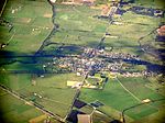
Koo Wee Rup

Koo Wee Rup is a town and satellite suburb in Victoria, Australia, 63 km south-east of Melbourne's Central Business District, located within the Shire of Cardinia local government area. Built on former marshland now converted to market gardens, Koo Wee Rup recorded a population of 4,047 at the 2021 census. Prior to December 1994 the suburb was part of the Shire of Cranbourne. The post office opened on 7 January 1891. In the early 1950s many Dutch and Italian families settled in the area. Prior to European settlement the area was occupied by the Bunurong Aboriginal people. It is from their language that the town's name derives. Ku-wirup is believed to mean "plenty of blackfish" or "blackfish swimming". Koo Wee Rup is Australia's largest asparagus-growing district. It is also a beef-farming and potato-growing area. The town was previously well known for its potato festival, which was held each March to raise funds for the Westernport Memorial Hospital (now Kooweerup Regional Health Service). Schools include Koo Wee Rup Primary School, St John the Baptist Primary School and Koo Wee Rup Secondary College. The town has an Australian rules football team competing in the West Gippsland Football League.
Excerpt from the Wikipedia article Koo Wee Rup (License: CC BY-SA 3.0, Authors, Images).Koo Wee Rup
Gardner Street, Melbourne
Geographical coordinates (GPS) Address Nearby Places Show on map
Geographical coordinates (GPS)
| Latitude | Longitude |
|---|---|
| N -38.198 ° | E 145.489 ° |
Address
Gardner Street 21
3981 Melbourne
Victoria, Australia
Open on Google Maps


