place

Hancock Field Air National Guard Base

1941 establishments in New York (state)DeWitt, New YorkEconomy of Syracuse, New YorkInstallations of the United States Air Force in New York (state)Installations of the United States Air National Guard
Military installations in New York (state)Radar stations of the United States Air Force
174 ATKW
174 ATKW

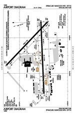
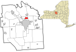
Hancock Field Air National Guard Base is a United States Air Force base, co-located with Syracuse Hancock International Airport. It is located 4.6 miles (7.4 km) north-northeast of Syracuse, New York, at 6001 East Molloy Road, Mattydale, NY 13211. The installation consists of approximately 350 acres (1.4 km2) of flight line, aircraft ramp and support facilities on the south side of the airport. Hancock Field is the home station of the New York Air National Guard's 174th Attack Wing (174 ATW), and the 274th Air Support Operations Squadron (274 ASOS). Both units are operationally gained by Air Combat Command (ACC). The base employs approximately 2,000 personnel consisting of full-time Active Guard and Reserve (AGR), Air Reserve Technicians (ART) and traditional part-time Air National Guardsmen. ANG personnel maintain the BAK-14 arresting gear on the airport's primary runway for emergency use by military tactical jet aircraft. They also operate an Air Force crash fire station that augments the airport's civilian Aircraft Rescue and Fire Fighting (ARFF) department. On 11 August 2008, it was reported that the 174th Fighter Wing would replace all F-16 Fighting Falcon fighter aircraft with MQ-9 Reaper unmanned combat aircraft. On 6 March 2010, the last 2 F-16Cs departed Hancock Field marking the end of F-16 aircraft operations at the base. Aircraft 85-1570 and 85-1561 made three low passes for the assembled crowd gathered to commemorate the end of manned aviation for the Wing. The unit then transitioned to the remotely piloted MQ-9 Reaper, and was re-designated as an Attack Wing with the new aircraft.

Excerpt from the Wikipedia article Hancock Field Air National Guard Base (License: CC BY-SA 3.0, Authors, Images).

Hancock Field Air National Guard Base
East Taft Road,

Geographical coordinates (GPS) Address Website Nearby Places
placeShow on map

Wikipedia: Hancock Field Air National Guard BaseContinue reading on Wikipedia

Geographical coordinates (GPS)

Latitude Longitude
N 43.111388888889 ° E -76.123611111111 °
placeShow on map

Address

Syracuse Hancock International Airport

East Taft Road
13057
New York, United States
mapOpen on Google Maps

Website
syrairport.org

linkVisit website

174 ATKW
174 ATKW
Share experience

Nearby Places

Sedgwick, Syracuse

Sedgwick is one of the 26 officially recognized neighborhoods of Syracuse, New York, United States. It borders four other Syracuse neighborhoods, with Northside to the north and west, Near Northeast to the southwest, Lincoln Park to the south, and Eastwood to the east. Sedgwick, and more specifically Sedgwick Farms, are an established, historic, affluent, and architecturally significant district in near northeast Syracuse which features the most elaborate, extensive, and eclectic collection of early-20th century residences in the city. The stately homes found in this neighborhood represent some of the finest works of Syracuse architects, landscape architects, interior designers, and builders, including Ward Wellington Ward, Dwight James Baum, Paul Hueber, Bonta and Taylor, Archimedes Russell, and Harry King. The John G. Ayling House was listed on the National Register of Historic Places in 2011.Sedgwick and Sedgwick Farms are well regarded for their architectural and landscape diversity. Winding boulevards and tree-lined streets feature noteworthy historical revival examples of the Italianate, Georgian Colonial, Dutch Colonial, Federal, Norman French, Spanish, and English Tudor pre-war residential architecture. The neighborhood is characterized by its Garden City town planning principles, bucolic tree-lined streets, and manicured landscaping. In 1977, the Sedgwick-James-Highland Preservation district was first established as the largest preservation district in Syracuse.The Sedgwick-James-Highland Preservation District contains approximately 285 residences, one church, Lincoln Junior High School, and a number of business establishments, several of which are residential conversions. The district divides itself into three distinct but contiguous sections: Upper James Street, the original Sedgwick Farms Land Tract, and a contiguous length of Highland Avenue with side streets Oak and DeWitt. These three areas are unified by the continuity of their architectural styles, urban form, and neighborhood character. The residences in these areas are among the finest in the city and approximately 95% of them were built in the first three decades of the twentieth century. Highland and James streets, laid out in the nineteenth century, run parallel and form a southwest-northeast axis for the district. Extending north from the center section of this axis is the Sedgwick Farms Tract. Sedgwick Drive is the main landscaped boulevard at the heart of Sedgwick Farms.