place

First United Church (Ottawa)

Anglican church buildings in OttawaCommons link is the pagenameGothic Revival architecture in OttawaGothic Revival church buildings in CanadaUnited Church of Canada churches in Ottawa
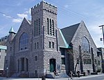
First United Church in Westboro Ottawa, Ontario, Canada

First United Church is a United Church of Canada congregation in Ottawa, Ontario, Canada. One of Ottawa's oldest congregations, the church formed in 1846.

Excerpt from the Wikipedia article First United Church (Ottawa) (License: CC BY-SA 3.0, Authors, Images).

First United Church (Ottawa)
Kent Street, (Old) Ottawa Centretown

Geographical coordinates (GPS) Address Phone number Website Nearby Places
placeShow on map

Wikipedia: First United Church (Ottawa)Continue reading on Wikipedia

Geographical coordinates (GPS)

Latitude Longitude
N 45.412084 ° E -75.696219 °
placeShow on map

Address

Ottawa Chinese-Canadian Heritage Centre

Kent Street 397
K2P 2B1 (Old) Ottawa, Centretown
Ontario, Canada
mapOpen on Google Maps

Phone number

call+16137097446

Website
chottawa.com

linkVisit website

First United Church in Westboro Ottawa, Ontario, Canada
Share experience

Nearby Places

Centretown
Centretown

Centretown is a neighbourhood in Somerset Ward, in central Ottawa, Ontario, Canada. It is defined by the city as "the area bounded on the north by Gloucester Street and Lisgar Street, on the east by the Rideau Canal, on the south by the Queensway freeway and on the west by Bronson Avenue." Traditionally it was all of Ottawa west of the Rideau Canal, while Lower Town was everything to the east. For certain purposes, such as the census and real estate listings, the Golden Triangle and/or Downtown Ottawa (between Gloucester/Lisgar and the Ottawa River) is included in Centretown and it is considered part of Centretown by the Centretown Citizens Community Association as well as being used in this way in casual conversation. The total population of Centretown (south of Gloucester Street) was 23,823 according to the Canada 2016 Census.Centretown is marked by a mix of residential and commercial properties. The main streets such as Bank Street and Elgin Street are largely commercial, while the smaller ones, notably MacLaren and Gladstone are more residential. Much of the area still consists of original single family homes, but there are newer infill and town house developments and low-rise and high-rise apartment buildings. A construction boom that began in the late nineties significantly increased the number of condominiums and other residential and commercial high-rise buildings north of Cooper Street.Landmarks include the Canadian Museum of Nature, Dundonald Park, Jack Purcell Park, McNabb Recreation Centre, the Ottawa Curling Club, the Sens Mile and the Ottawa Central Bus Station.

Ottawa Central Station

Ottawa Central Station was the main inter-city bus station in Ottawa, Ontario, Canada. It was located 1.5 km south of downtown Ottawa in the Centretown neighbourhood and served buses from Greyhound Canada, Ontario Northland and Autobus Gatineau. It closed on June 1, 2021, and the land it sat on is now owned by Brigil, a real estate developer, who plans to build a multi-use space for housing, dining, retail, and other businesses.Ottawa Central Station was located at 265 Catherine Street, between Lyon Street and Kent Street. Catherine Street lies directly north of Ontario Highway 417 (known locally as the Queensway), which is the main expressway through Ottawa. The former station was accessible from highway 417 exits 120 (eastbound) and 119 (westbound). The station's main entrance faced south towards Catherine Street and the 417. On the north side of the station building, buses called at 14 outdoor bus stands with adjoining indoor gates. The front of the buses were partially covered by a roof overhang. The property it sat on is located one block west of Bank Street, a major north-south commercial street in Ottawa. Continuing north on Bank Street leads to downtown and the main government and business district, while south of highway 417, the street passes through the more residential neighbourhood of the Glebe on its way to Landsdowne Park and the Rideau Canal. Nearby landmarks include the Canadian Museum of Nature on Metcalfe Street and beyond that, the southern end of Elgin Street, a north-south commercial street with many small shops, restaurants and bars. Ottawa Central Station was located roughly 5 kilometres (3.1 mi) west of the Ottawa Train Station and 11 kilometres (6.8 mi) north of Ottawa Macdonald–Cartier International Airport.