Cleveland Street, London
FitzroviaPoor law infirmariesStreets in the City of WestminsterStreets in the London Borough of CamdenUse British English from June 2015

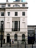
Cleveland Street in central London runs north to south from Euston Road (A501) to the junction of Mortimer Street and Goodge Street. It lies within Fitzrovia, in the W1 post code area. Cleveland Street also runs along part of the border between Bloomsbury (ward) which is located in London Borough of Camden, and West End (ward) and Marylebone High Street (ward) in the City of Westminster. In the 17th century, the way was known as the Green Lane, when the area was still rural, or Wrastling Lane, after a nearby amphitheatre for boxing and wrestling.
Excerpt from the Wikipedia article Cleveland Street, London (License: CC BY-SA 3.0, Authors, Images).Cleveland Street, London
Cleveland Street, London Fitzrovia (London Borough of Camden)
Geographical coordinates (GPS) Address Nearby Places Show on map
Geographical coordinates (GPS)
| Latitude | Longitude |
|---|---|
| N 51.520867 ° | E -0.139196 ° |
Address
Cleveland Street
Cleveland Street
W1W 6YX London, Fitzrovia (London Borough of Camden)
England, United Kingdom
Open on Google Maps


