place

Shelby Park, Louisville

1900s establishments in KentuckyGerman-American culture in Louisville, KentuckyJefferson County, Kentucky geography stubsLouisville, Kentucky stubsNeighborhoods in Louisville, Kentucky
Populated places established in the 1900s
Carnegie Library in Louisville

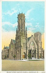
Shelby Park is a neighborhood two miles southeast of downtown Louisville, Kentucky USA named after Kentucky's first governor, Isaac Shelby. Shelby Park has always been considered a working-class neighborhood. It was first populated by German immigrants in the early 1900s. By the 1950s, the neighborhood was majority African American. Today, Shelby Park is a blend of ethnic and economic diversity. People from all walks of life co-exist in a vibrant, art-filled community. The Shelby Park neighborhood is known for its 17-acre park by the same name. Shelby Park was designed by the Olmsted Firm in 1907 and is the only Olmsted park in Louisville with a Carnegie library designed by Arthur Loomis. A gothic revival church at Oak and S. Shelby Streets constructed around 1886 is another architectural and historical landmark. Most of the residential homes in Shelby Park were constructed around 1900 to 1910 and are shotgun-style cottages and camelbacks, with some two-story brick federal style buildings in the mix, too. Shelby Park is home to Logan Street Market, Louisville's first and only year-round indoor market with food vendors, artisans, coffee bar, brewery and Farmer's Market located at Logan and Saint Catherine Streets in Shelby Park that opened its doors in October, 2019 Shelby Park is bounded by the CSX rail tracks, Kentucky Street, and I-65 and borders Germantown, Smoketown and Old Louisville. As of 2000, the population of Shelby Park was 3,204 [1].

Excerpt from the Wikipedia article Shelby Park, Louisville (License: CC BY-SA 3.0, Authors, Images).

Shelby Park, Louisville
Camp Street, Louisville

Geographical coordinates (GPS) Address Nearby Places
placeShow on map

Wikipedia: Shelby Park, LouisvilleContinue reading on Wikipedia

Geographical coordinates (GPS)

Latitude Longitude
N 38.232777777778 ° E -85.745833333333 °
placeShow on map

Address

Camp Street
40203 Louisville
Kentucky, United States
mapOpen on Google Maps

Carnegie Library in Louisville
Share experience

Nearby Places

Louisville metropolitan area

The Louisville metropolitan area is the 43rd largest metropolitan statistical area (MSA) in the United States. It had a population of 1,395,855 in 2020 according to the latest official census, and its principal city is Louisville, Kentucky. The metropolitan area was originally formed by the United States Census Bureau in 1950 and consisted of the Kentucky county of Jefferson and the Indiana counties of Clark and Floyd. As surrounding counties saw an increase in their population densities and the number of their residents employed within Jefferson County, they met Census criteria to be added to the MSA. Jefferson County, Kentucky, plus eleven outlying counties – seven in Kentucky and four in Southern Indiana – are now a part of this MSA. Two other counties, one each in Kentucky and Indiana, were part of the MSA in the 2000 and 2010 U.S. Censuses, but were spun off by the Census Bureau into their own Micropolitan Statistical Areas in 2013 and 2018 respectively. The formal name given to the area by the Census Bureau is the Louisville–Jefferson County, Kentucky–Indiana, metropolitan statistical area, though it is regularly referred to as Kentuckiana. It is now the primary MSA of the Louisville/Jefferson County–Elizabethtown–Bardstown, KY-IN Combined Statistical Area, created by the United States Bureau of the Census in 2000 and recently redefined in 2018. The combined statistical area (CSA) adds the counties of Hardin County, Kentucky, LaRue County, Kentucky, Jefferson County, Indiana, and Nelson County, Kentucky and comprises the Louisville–Jefferson County MSA, the Elizabethtown–Fort Knox, Kentucky, MSA, the Bardstown, Kentucky, micropolitan statistical area and the Scottsburg, Indiana micropolitan statistical area. In 2020, the Census Bureau measured the combined statistical area's population at 1,601,309.