place

Penycloddiau

Hillforts in FlintshireHistory of FlintshireMarilyns of WalesMountains and hills of FlintshirePages with Welsh IPA
Use British English from July 2022
Penyclodd RO
Penyclodd RO

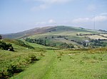
Penycloddiau is a hill in Flintshire, Wales, and one of five Marilyns in the Clwydian Range. The hill, like Foel Fenlli and Moel Arthur to the south, has an Iron Age hillfort at its summit. It covers 26 hectares (64 acres) making it one of the largest hillforts in Wales. In 2017, excavations by the Clywdian Range Archaeology Group (CRAG) unearthed a significant number of 4,000-year-old stone tools from the Bronze Age, the discovery indicates human activity occurred much earlier than first thought in the area.Penycloddiau is crossed by the Offa's Dyke Path and the Clwydian Way, two long distance footpaths that traverse the hills in this area. A free car park exists at the bwlch between Penycloddiau and Moel Arthur, where two footpaths lead to the summit.

Excerpt from the Wikipedia article Penycloddiau (License: CC BY-SA 3.0, Authors, Images).

Penycloddiau
Byway Open to All Traffic, St Asaph Llandyrnog

Geographical coordinates (GPS) Address External links Nearby Places
placeShow on map

Wikipedia: PenycloddiauContinue reading on Wikipedia

Geographical coordinates (GPS)

Latitude Longitude
N 53.20008 ° E -3.30834 °
placeShow on map

Address

Penycloddiau Hill Fort

Byway Open to All Traffic
LL16 4LY St Asaph, Llandyrnog
Wales, United Kingdom
mapOpen on Google Maps

linkWikiData (Q7165400)
linkOpenStreetMap (1077048344)

Penyclodd RO
Penyclodd RO
Share experience

Nearby Places

Moel-y-Parc transmitting station

The Moel-y-Parc transmitting station is situated on Moel y Parc, a hill in north-east Wales at the northern end of the Clwydian range, close to the town of Caerwys and several miles (kilometres) north-east of Denbigh. It was built in 1962/1963 by the IBA to bring 405-line VHF ITV television to North Wales and it has been on the air since 1963. Its original height of 229 metres (751 ft) made it the tallest structure in North Wales and it stands on land that is itself about 335 metres (1,099 ft) above sea level. In 1965, VHF television transmissions from the BBC commenced from the site. With the addition of the UHF aerials in 1969, the mast height increased to 235 metres (771 ft) high. Its official coverage area includes parts of Flintshire, Denbighshire and Wrexham (although the majority of Wrexham is in a blindspot of direct transmission from Moel-y-Parc, its analogue transmissions were relayed via the Wrexham-Rhos transmitting station). A network of relay stations extends television coverage as far as Colwyn Bay in the west and Bala in the south. VHF television services from both BBC and ITV were discontinued in January 1985 as the 405-line TV system was switched off across the UK as a whole. Moel-y-Parc's UHF channel allocation made it a "Group B" transmitter, but with the roll-out of the UK's first digital TV services in 1998, a "Group W" wideband aerial was needed. The site reverted to being a "Group B" transmitter at digital switchover (DSO). Technically, with the advent of the temporary MUXES 7 and 8 Moel Y Parc became a K group, and is due to remain so at its 700 MHz clearance. However most B group aerials will still work on all Moel's transmitted DTT channels (see graph). The site is currently administered by Arqiva.