Electoral district of Barron River
Cairns, QueenslandElectoral districts of QueenslandFar North QueenslandPages with disabled graphsUse Australian English from April 2020
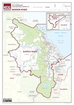
Barron River is an electoral district of the Legislative Assembly in the Australian state of Queensland.Created at the 1971 redistribution, it currently covers the northern suburbs of Cairns, as well as Kuranda. The Barron River from which the electorate derives its name runs through its centre. It is bordered by the districts of Cook to the north and west, Cairns to the southeast and Mulgrave to the south.
Excerpt from the Wikipedia article Electoral district of Barron River (License: CC BY-SA 3.0, Authors, Images).Electoral district of Barron River
Wistaria Street, Cairns Holloways Beach (Holloways Beach)
Geographical coordinates (GPS) Address Nearby Places Show on map
 Continue reading on Wikipedia
 Geographical coordinates (GPS)
| Latitude | Longitude |
|---|---|
| N -16.85 ° | E 145.73333333333 ° |
Address
Wistaria Street
Wistaria Street
4878 Cairns, Holloways Beach (Holloways Beach)
Queensland, Australia
Open on Google Maps


