South Gare

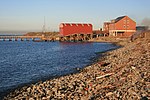
South Gare is an area of reclaimed land and breakwater on the southern side of the mouth of the River Tees in Redcar and Cleveland, England. It is accessed by taking the South Gare Road (private road) from Fisherman's Crossing at the western end of Tod Point Road in Warrenby. Before the building of South Gare, permanent dry land stopped at Tod Point, at the western end of Warrenby, and there was only Coatham Sands and the mudflats of Bran Sands. The creation of South Gare extends this by a further 2.5 miles (4.0 km). The building of South Gare offers a safe harbour in stormy weather to ships off the coast and allowed for the dredging of the River Tees entrance. South Gare itself was a settlement but the houses there were demolished many years ago.
Excerpt from the Wikipedia article South Gare (License: CC BY-SA 3.0, Authors, Images).South Gare
South Gare Road,
Geographical coordinates (GPS) Address Nearby Places Show on map
Geographical coordinates (GPS)
| Latitude | Longitude |
|---|---|
| N 54.640342 ° | E -1.139145 ° |
Address
South Gare Road
South Gare Road
TS10 5NX
England, United Kingdom
Open on Google Maps


